
Orbis terrarum nova et accuratissima tabula
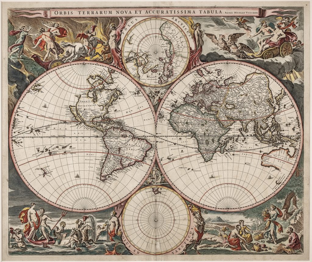
Nicolaes Visscher I was an Amsterdam engraver, mapmaker, and publisher who continued the Visscher family business after the death of his father, Claes Jansz. Visscher, in 1652. The Visscher firm was closely associated with the Dutch market for wall maps, atlas maps, Bible maps, and separately issued prints, and its plates were often revised, reissued, and adapted across several decades. This double-hemisphere world map includes two smaller polar projections above and below the main hemispheres.
The map was first published in Johannes Janssonius's Atlas novus, vol. 1, issued in Amsterdam in 1658 (see 34, 43, 107, 206, 255, 282). It was subsequently reused, in Visscher-family atlases, including the Atlas contractus, and was also sold separately for inclusion in composite atlases. This map is among the earliest Dutch world maps to abandon the vast continuous Terra Australis Incognita, that had dominated sixteenth- and early seventeenth-century cartography. In its place Visscher incorporated the results of Abel Tasman's voyages of 1642–43 and 1644, including Tasmania, New Zealand, and parts of the northern Australian coastline, giving greater prominence to observed geography than to inherited speculation.
The map is richly decorated with four elaborate mythological scenes designed by Nicolaes Berchem, each symbolising one of the four classical elements. Fire depicts the abduction of Persephone by Hades, with the nymph Cyane attempting to intervene. Air shows Zeus and Hera traversing the heavens in an eagle-drawn chariot accompanied by putti. Water presents Poseidon and Aphrodite emerging from the sea in a chariot drawn by hippocampi, surrounded by tritons and nymphs. Earth portrays a pastoral harvest scene presided over by Demeter, holding a cornucopia as mortals present the fruits of agricultural abundance.
Within the collection, this map is closely connected with Visscher’s earlier Bible world maps (25and 93), which preserve an older double-hemisphere format and biblical publishing context. It also relates to his separately published world map of c. 1652 (287), with its elaborate ethnographic and allegorical border. Compared with Verbiest’s earlier world map (313), where Terra Australis nondum cognita still occupies the southern margin, 129shows the shift toward a post-Tasman world image, in which the speculative southern continent is largely replaced by recorded Dutch discoveries in New Holland, Van Diemen’s Land, and New Zealand.
Visscher I, Nicolaes (1618–1679)
Atlas novus, vol. 1, Amsterdam: Johannes Janssonius, 1658
1658, first
Copperplate engraving
129
R2 Very rare - one or two copies appear on the market