
Mar del Zur Hispanis Mare Pacificum
Johannes Janssonius was an Amsterdam publisher, bookseller, and mapmaker who became one of the leading figures in the continuation of the Mercator-Hondius atlas tradition. In 1612 he married Elisabeth Hondius, daughter of Jodocus Hondius I, and in 1630 he entered into partnership with his brother-in-law Henricus Hondius. Their Atlantis maioris appendix, sive pars altera of 1630 expanded the Mercator-Hondius atlas project and placed the firm in direct competition with the Blaeu publishing house.
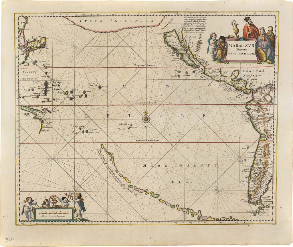
Beginning in 1638, the atlas was renamed Atlas novus and expanded to three volumes. A fourth volume was added in 1646, followed by a fifth in 1650, which was divided into two parts—Atlas maritimus (Part 1) and Atlas antiquus (Part 2). Part 1 included this map of the Pacific Ocean that features several inherited geographical conjectures. Beginning in 1638, the atlas was renamed Atlas novus and expanded to three volumes. A fourth volume followed in 1646, and a fifth in 1650, which was divided into two parts—Atlas maritimus (Part 1) and Atlas antiquus (Part 2). Part 1 included this map of the Pacific Ocean that features several intriguing myths. One prominent myth depicted on the map is a chain of islands stretching across the Pacific from the tip of South America to Tropicus Capricorni. These are accompanied by the inscription: “Infulas esse a nova Guinea usq. ad Fretum Magellanicum, affirmat Hernandus Galego, qui ad eas explorandas missus fuit a Rege Hispaniae Anno 1576, ” meaning “Hernandus Galego, sent by the King of Spain in 1576, asserts that there are islands from New Guinea to the Strait of Magellan.” This mythical chain of islands also appears on other contemporary maps, such as Henricus Hondius’s Polus Antarcticus (#18 and #114).
Another common misconception in seventeenth-century cartography was representing California as an island. On this map, it is separated from a large, mysterious northern landmass labelled “Terra Incognita” by the Fretum Anian (Strait of Anian). The map also details Jan Carstensz.'s discoveries along the western coast of Cape York Peninsula in 1623, including the place names recorded during his expedition. In this first state, the map does not incorporate Abel Tasman’s discoveries in Australia; they appear in the second state (# 43).
Janssonius, Johannes (1588–1664)
Atlas novus, vol. 5, part 1. Amsterdam: Johannes Janssonius, 1650
1650, first
Copperplate engraving
282
R1 Extremely rare - occasionally seen on the market