
Orbis terrarum typus de integro in plurimis emendatus, auctus, et incunculis illustratus
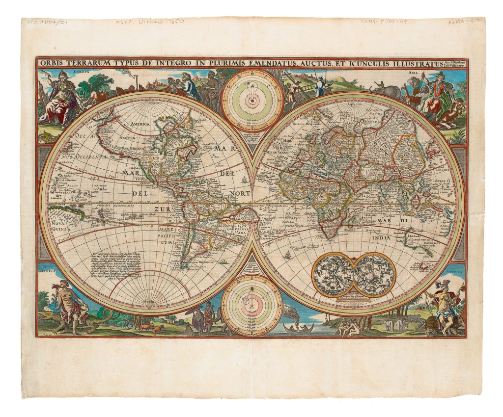
Nicolaes Visscher I was an Amsterdam engraver, mapmaker, and publisher who continued the Visscher family business after the death of his father, Claes Jansz. Visscher, in 1652. Working from one of the most productive Dutch map-publishing firms of the seventeenth century, he issued maps for atlases, Bibles, and separate publication, often reworking existing plates while updating their geography and decorative programmes for new audiences. This double-hemisphere world map was first published c. 1650 in Amsterdam by Paulus Aertsz. van Ravesteyn for inclusion in editions of the Dutch Statenbijbel. Simon Dewez identifies it as a reworking of an earlier 1614 world map (Shirley 288) by Nicolaes Visscher’s father, Claes Jansz. Visscher. A surviving copy of the 1614 map is preserved at the Badische Landesbibliothek in Karlsruhe. Faint traces of the earlier plate remain visible, including lettering for Tierra del Fuego and the coastline of Magellanica beneath the south-east coast of New Guinea.
The map captures a moment when Dutch discoveries were reshaping the image of the world, but before that image had fully stabilised. It incorporates the results of Abel Tasman’s first voyage of 1642–1643, naming Tasmania as A. Van Diemen’s Landt, but predates his 1644 voyage and therefore omits the northern coast of Australia. The second state, issued in 1660, updated the geography further by adding the coastline of New Zealand. Several earlier Dutch encounters with Australia are recorded, including Dirk Hartog’s 1616 landfall, the 1619 voyage of Frederik de Houtman and Jacob d’Edel near present-day Perth, the charting of the south-western coast by the Leeuwin in 1622, Jan Carstensz.’s exploration of Cape York in 1623, Pieter Nuyts’s survey of the southern coast in 1627, and Gerrit Frederiksz. de Witt’s grounding in 1628. Willem Jansz.’s 1606 landfall on Cape York Peninsula is not shown.
The map’s decorative programme places global geography within a wider cosmographical framework. Personifications of the four continents occupy the corners, while two central diagrams contrast the Copernican heliocentric and Ptolemaic geocentric systems. Celestial hemispheres appear to the south-east, and an inscription in the south-west recounts the voyages of Christopher Columbus, Amerigo Vespucci, and the early circumnavigators of the globe.
Visscher I, Nicolaes (1618–1679)
Biblia (Statenbijbel) Amsterdam: Paulus Aertsz. van Ravesteyn, 1650
1650, first
1660, second, includes the coastline of New Zealand
Copperplate engraving
25
R1 Extremely rare - occasionally seen on the market