
Die eigentliche und warhafftige gestalt der Erden und des Meers. Cosmographia universalis
Heinrich Bünting was a Protestant theologian, pastor, and biblical geographer from Hanover, educated at the University of Wittenberg. His best-known work, Itinerarium sacrae scripturae, first published at Magdeburg in 1581, was a geographical guide to the places of Scripture. It was designed for readers who wished to understand sacred history through the physical landscapes of the Old and New Testaments. The work combined scriptural commentary, travel narrative, and imaginative cartography, and included a group of distinctive woodcut maps, among them Bünting’s well-known figurative maps of the world as a cloverleaf, Europe as a crowned woman, and Asia as Pegasus.
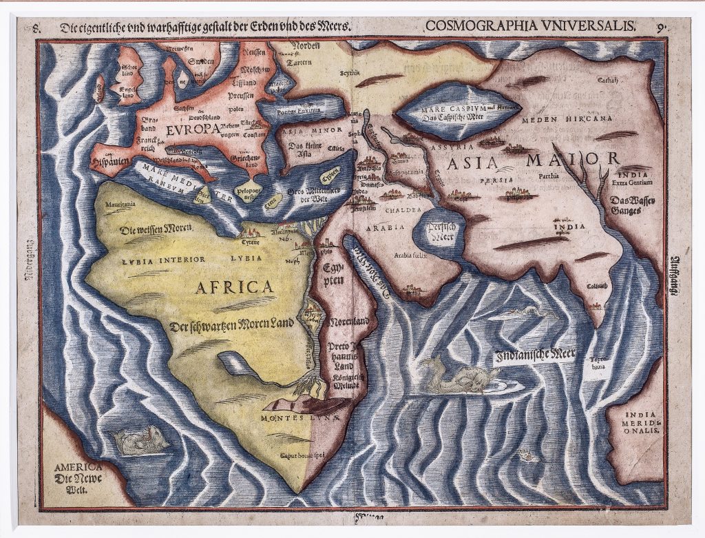
This woodcut world map is less overtly emblematic than Bünting’s cloverleaf design, but it is no less interpretive. It presents Europe, Africa, and Asia as the principal inhabited continents, with part of America appearing at the western edge as America Die Newe Welt. The title announces the map as the “true and faithful form of the earth and the sea, ” yet its geography combines classical authority, biblical history, medieval legend, and late sixteenth-century cosmographic tradition rather than offering a strictly navigational image of the world. Africa receives particular attention. The Nile rises from the Montes Lunae, or Mountains of the Moon, and flows from a large interior lake, following a long classical and medieval geographical tradition. Northern Africa is labelled Die weissen Moren (“the White Moors”), while sub-Saharan Africa is identified as Der schwartzen Moren Land (“Land of the Black Moors”). The map also marks Meroe, associated in classical geography with Nubian kingship, and places nearby Preto Hannes Land, the land of Prester John. This fabled Christian ruler and kingdom, long sought by European writers and travellers, reflects the persistence of medieval legend within early modern biblical geography.
The Indian Ocean is especially imaginative. Taprobana, the classical name generally associated with Sri Lanka, appears south of India, while a large southern landmass labelled India Meridionalis occupies the lower right of the map. This southern extension recalls older ideas of an enlarged southern or southeastern Asia rather than the later mapping of Australia. Four sea creatures animate the surrounding waters, giving visual form to the marvels, dangers, and uncertainties of distant seas. The map also retains several inherited geographical ideas, including the enclosed form of the Caspian Sea, the Mare Mediteraneum, the Mare Caspium vel Hircanum, and a compact rendering of Europe and Asia shaped by biblical and classical place names. Its arrangement privileges the scriptural and historical world of Europe, Africa, and western Asia, while the newly encountered western hemisphere appears only at the margin. As a whole, the map shows how Bünting’s biblical geography absorbed classical models, travel literature, legendary kingdoms, and new global information into a single cosmographic image.
Bünting, Heinrich (1545–1606)
Itinerarium sacrae scripturae, Magdeburg, Paul Donat, for Ambrosius Kirchner, 1581
1608–1616, Later German issue
Woodcut
116
R3 Uncommon - dealers can usually obtain a copy