
Iehova
Claes Jansz. Visscher was an Amsterdam engraver, publisher, and map seller whose firm became one of the important Dutch map publishing houses of the first half of the seventeenth century. In 1611 he established his publishing house on the Kalverstraat, close to leading contemporaries such as Pieter van den Keere and Jodocus Hondius I. The firm was continued by his son Nicolaes Visscher I and later by his grandson Nicolaes Visscher II.
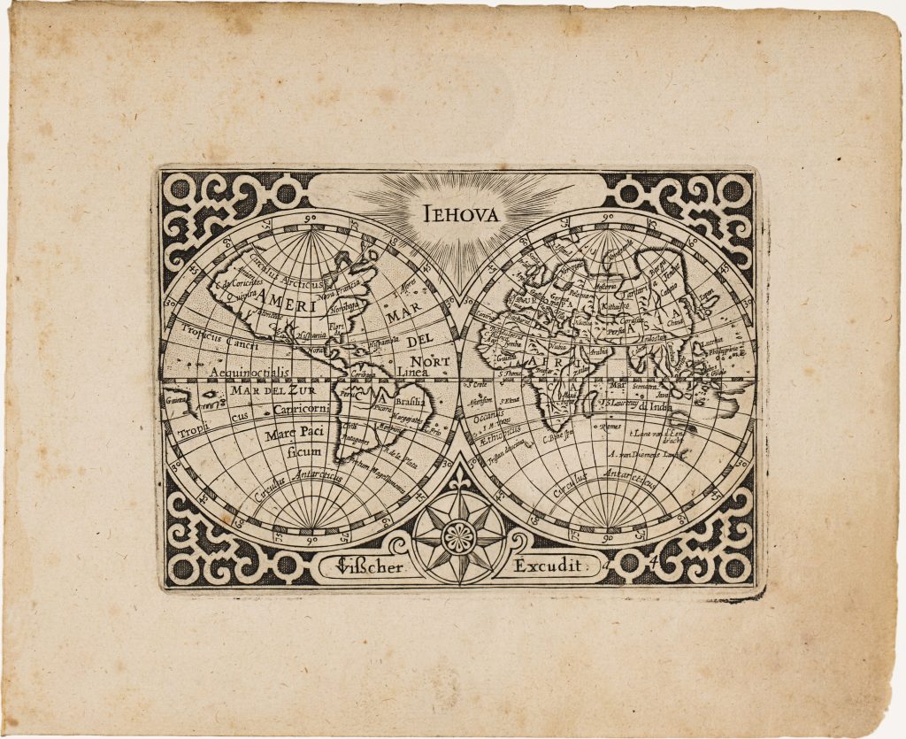
n 1649 Visscher reworked and expanded Barent Langenes’s Caert-thresoor, an older small-format atlas first published in Amsterdam in 1598 by Cornelis Claesz. After Claesz.’s death in 1609, the atlas plates passed through several owners before being acquired by Visscher, who reissued the material as Tabularum geographicarum contractarum libri quatuor denuo recogniti. The compact atlas was divided into four parts: Europae, Asiae, Africae, and Americae. Alongside the inherited Caert-thresoor plates, Visscher added twenty-three newly engraved maps, among them ’t Landt van de Eendracht (12), Anthoni van Diemens Landt (11), Java Maior (371), and several plates engraved by Benjamin Wright (369, 370). The atlas also includes two revised world maps, Typus Orbis Terrarum (292) and this map, Iehova, both originally engraved by Jodocus Hondius I for the 1598 Caert-thresoor (294and 296).
In this revised state, Visscher retained the essential structure of the original double-hemisphere projection, including the strapwork frame, the compass rose below, and the central inscription “IEHOVA, ” a Latinised form of the Hebrew name for God, placed between the two hemispheres. Hondius’s signature was replaced with Visscher’s, and the plate discreetly marked “a 4” within the strapwork at lower right. The most consequential changes appear in the southern world. In the original version, Terra Australis incognita formed an extensive continuous landmass across the southern hemisphere. In Visscher’s revision, this speculative continent has been removed. In the emerging eastern outlines of ’t Landt van d’Eendracht and A. van Diemen’s Lant, register Dutch discoveries on the western Australian coast and in Tasmania, especially those associated with Abel Tasman’s 1642–1643 voyage.
Within the collection, this map is closely connected with its companion revised world map, Typus orbis terrarum (292), also reworked from the Caert-thresoor plates. It also relates directly to Claes Jansz. Visscher’s newly engraved Australian maps in the same atlas (11and 12), and to later Visscher world maps (25, 93, 129, and 287), which show the continuing revision of world geography after Tasman.
Visscher, Claes Jansz. (1587–1652)
Tabularum geographicarum contractarum libri quatuor denuo recogniti, Amsterdam: Claes Jansz. Visscher, 1649
1649, first
Copperplate engraving
293
R1 Extremely rare - occasionally seen on the market