
Typus orbis terrarum
Claes Jansz. Visscher was an Amsterdam engraver, publisher, and map seller whose firm became one of the important Dutch map publishing houses of the first half of the seventeenth century. In 1611 he established his publishing house on the Kalverstraat, close to leading contemporaries such as Pieter van den Keere and Jodocus Hondius I. The firm was continued by his son Nicolaes Visscher I and later by his grandson Nicolaes Visscher II.
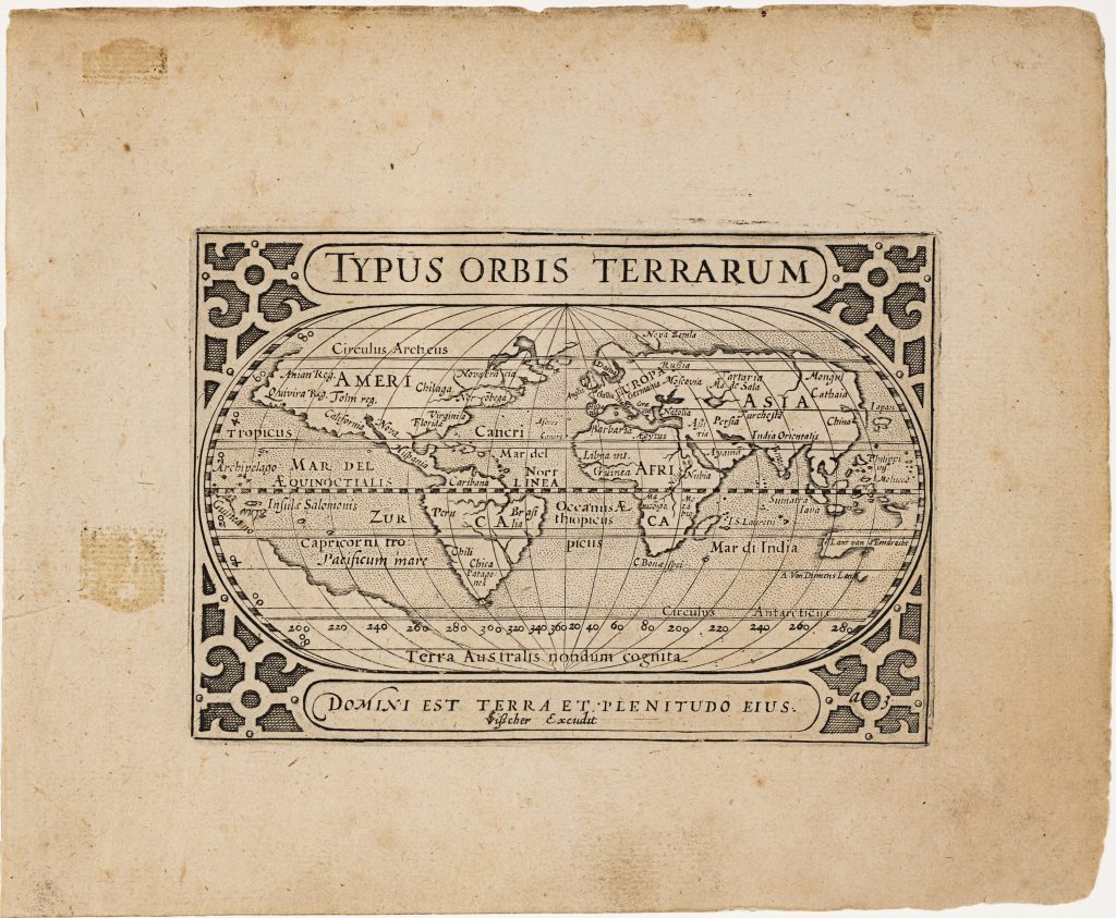
In 1649 Claes Jansz. reworked and expanded Barent Langenes’s Caert-thresoor, an older small-format atlas first published in Amsterdam in 1598 by Cornelis Claesz. After Claesz.’s death in 1609, the atlas plates passed through several owners before being acquired by Visscher who reissued the material as Tabularum geographicarum contractarum libri quatuor denuo recogniti. The compact atlas was divided into four parts: Europae, Asiae, Africae, and Americae. Alongside the inherited plates, Visscher added twenty-three newly engraved maps, among them Anthoni van Diemens Landt (11), ’t Landt van de Eendracht (12), Iava Maior (371), and several plates engraved by Benjamin Wright (369, 370). The atlas also included two revised world maps, this map Typus Orbis Terrarum and Iehova (293), both originally engraved by Jodocius Hondius I for the 1598 Caert-thresoor (294and 296).
In this revised state, Visscher retained the essential structure of the original oval-projection, including the strapwork frame, the oval title cartouche, and the Psalm 24: 1 inscription Domini est terra et plenitudo eius (“The earth is the Lord’s, and the fullness thereof”). Hondius’s signature has been replaced with Visscher’s, and the plate discreetly marked “a-3” within the strapwork at lower right. The most significant changes occur in the southern world. In the original version, Terra Australis nondum cognita formed an extensive, continuous landmass, including the toponym Psitacorum regio. In Visscher’s revision, much of that speculative continent has been removed. A remnant coastline remains in the western hemisphere south of South America, extending northward from the Antarctic Circle toward Guinea Nova. In the eastern hemisphere, the old southern landmass has been replaced by the toponyms t'Lant van d'Eendracht and A. van Diemen's Lant, reflecting Dutch discoveries in Australia and Tasmania, especially those associated with Abel Tasman’s 1642–1643 voyage.
Within the collection, this map is closely connected with its companion revised world map, Iehova (293), also reworked from the Caert-thresoor plates. It also relates directly to Claes Jansz. Visscher’s newly engraved Australian maps in the same atlas (11and 12), and to later Visscher world maps (25, 93, 129, and 287), which show the continuing revision of world geography after Tasman.
Visscher, Claes Jansz. (1587–1652)
Tabularum geographicarum contractarum libri quatuor denuo recogniti, Amsterdam: Claes Jansz. Visscher, 1649
1649, first
Copperplate engraving
292
R1 Extremely rare - occasionally seen on the market