
T'Landt van de Eendracht
Claes Jansz. Visscher was an Amsterdam engraver, publisher, and map seller whose firm became one of the important Dutch map publishing houses of the first half of the seventeenth century. In 1611 he established his publishing house on the Kalverstraat, close to leading contemporaries such as Pieter van den Keere and Jodocus Hondius I. The firm was continued by his son Nicolaes Visscher I and later by his grandson Nicolaes Visscher II.
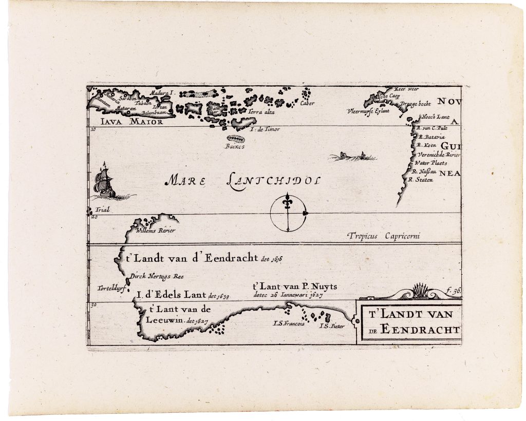
In 1649 Claes Jansz. reworked and expanded Barent Langenes’s Caert-thresoor, an older small-format atlas first published in Amsterdam in 1598 by Cornelis Claesz. After Claesz.’s death in 1609, the atlas plates passed through several owners before being acquired by Visscher who reissued the material as Tabularum geographicarum contractarum libri quatuor denuo recogniti. The compact atlas was divided into four parts: Europae, Asiae, Africae, and Americae. Alongside the inherited plates, Visscher added twenty-three newly engraved maps, among them this map, ’t Landt van de Eendracht, Anthoni van Diemens Landt (11), Iava Maior (371), and several plates engraved by Benjamin Wright (369, 370). The atlas also included two revised world maps: Typus Orbis Terrarum (292) and Iehova (293), both originally engraved by Jodocius Hondius I for the 1598 Caert-thresoor (294and 296). The title of this map refers to the ship Eendracht ("Concord"), commanded by Dirk Hartog, which in 1616 encountered and charted a substantial stretch of the western Australian coast. The map extends geographically from approximately 5°S to 35°S, graduated at one-degree intervals, and spans from Java to the western and northern coasts of Australia. The Tropic of Capricorn is marked, though no longitudes are shown. A simple compass rose appears in the lower portion of the plate.
The western coastline of Australia is delineated with a sequence of Dutch toponyms commemorating voyages between 1616 and 1627, including I. d’Edels Lant, ’t Landt van de Leeuwin, and other coastal designations. The sea between the Australian mainland and the Indonesian archipelago is labelled Mare Lantchidol, a Latinised form of an Indigenous name recorded during Abel Tasman’s voyage and subsequently adopted in Dutch cartography. Several Indonesian islands are depicted, including Madura, Iava maior, Timor, Baixos, Batulier I., Terra alta, Caber, and Vleermuyse Eylant, situating the Australian coastline within the broader VOC sphere of navigation. The plate also contains chronological errors. I.d'Edels Lant det. 1639 should read 1619, referring to its discovery by Frederik de Houtman and Jacob d’Edel aboard the Dordrecht and Amsterdam. Similarly, t'Lant van de Leeuwin det. 1627 should read 1622, marking the voyage of the Leeuwin, which recorded the southernmost Dutch landfall on the western coast of the Southland.
Within the collection, this map is closely connected with Visscher’s related Anthoni van Diemens Landt (11), which presents Van Diemen’s Land and the southern coast of New Holland. It also relates to Visscher’s revised world maps (292and 293), where the older speculative southern continent is partly replaced by Dutch discoveries in New Holland, and to later maps of the region by François Valentijn (177), John Thornton (102), and Gilles Robert de Vaugondy (17).
Visscher, Claes Jansz. (1587–1652)
Tabularum geographicarum contractarum libri quatuor denuo recogniti, Amsterdam: Claes Jansz. Visscher, 1649
1649, first
Copperplate engraving
12
R1 Extremely rare - occasionally seen on the market