
Typus orbis terrarum
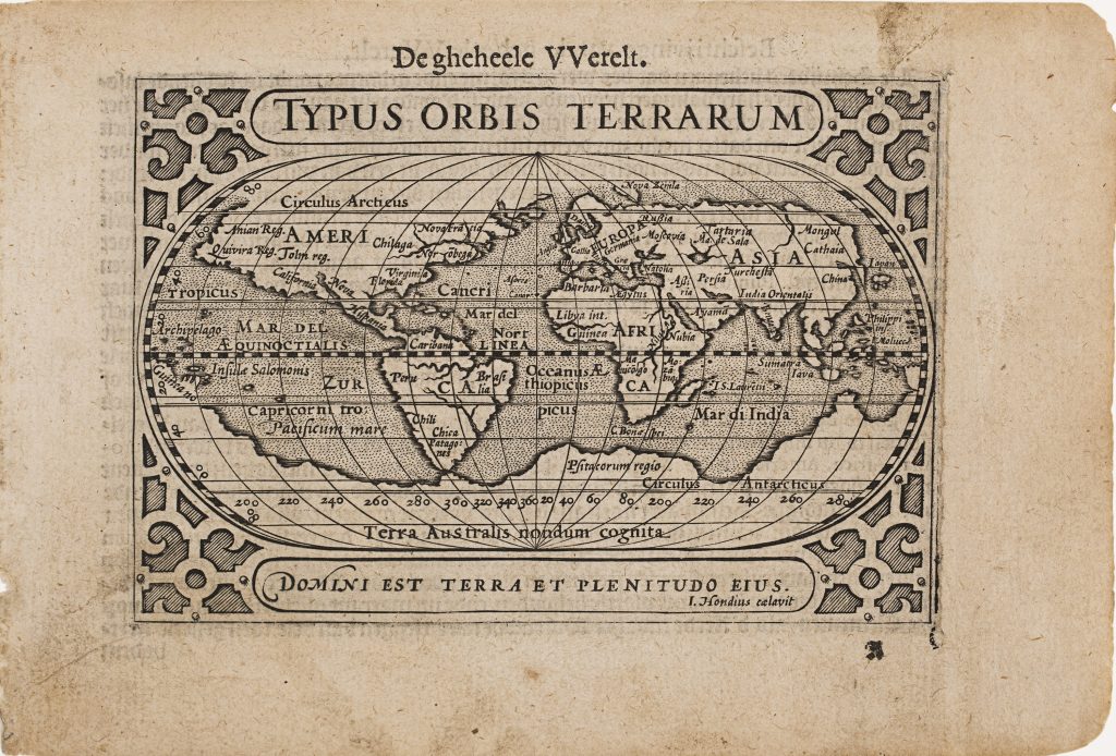
Barent Langenes was a Middelburg publisher associated with the compact Dutch atlas Caert-Thresoor, first issued in 1598 and distributed through the Amsterdam publisher Cornelis Claesz. Conceived as a small-format alternative to larger atlases, the work combined terrestrial, maritime, and cosmographical material and was later expanded into Latin, French, and German editions. This first-issue world map appeared in the cosmographical opening section of the atlas. It served as the opening map, appearing as the first leaf of section A and marked by the printer’s signature “A” at lower right.
Engraved by Jodocus Hondius, the map closely follows the world map engraved by Philip Galle for the 1584 Epitome of Abraham Ortelius’s Theatrum Orbis Terrarum (252). The hemispheres are enclosed within decorative strapwork and accompanied by the biblical inscription Domini est terra et plenitudo eius — “The earth is the Lord’s, and the fullness thereof” — from Psalm 24: 1. The inscription gives the small map a theological as well as geographical framing.
The map preserves late sixteenth-century geographical conventions and uncertainties. In the Americas, it includes California, Norrobega, Virginia, and Patagones, while across the southern hemisphere Terra Australis nondum cognita forms a continuous conjectural landmass. The Solomon Islands appear as Insulae Salomonis, reflecting the Latinised nomenclature used in contemporary European mapping.
This map is closely connected with the other Langenes works in the collection from Caert-Thresoor and its later editions, including the celestial chart De Hemelsche Cloots (295), the terrestrial globe diagram De Cloot der Aerden (296), the map of New Guinea and the Solomon Islands (383), and the East Indies map (388). It later served as the basis for revised states issued in 1649 by Claes Jansz. Visscher in Tabularum geographicarum contractarum libri quatuor denuo recogniti, where it reappeared as Typus Orbis Terrarum (292).
Langenes, Barent (fl. 1598–1609)
Caert-Thresoor, Middelburg: Barent Langenes, 1598
1598, first
Dutch, French, Latin, and German editions between 1598 and 1650
Copperplate engraving
294
R1 Extremely rare - occasionally seen on the market