
Theatrum orbis terrarum
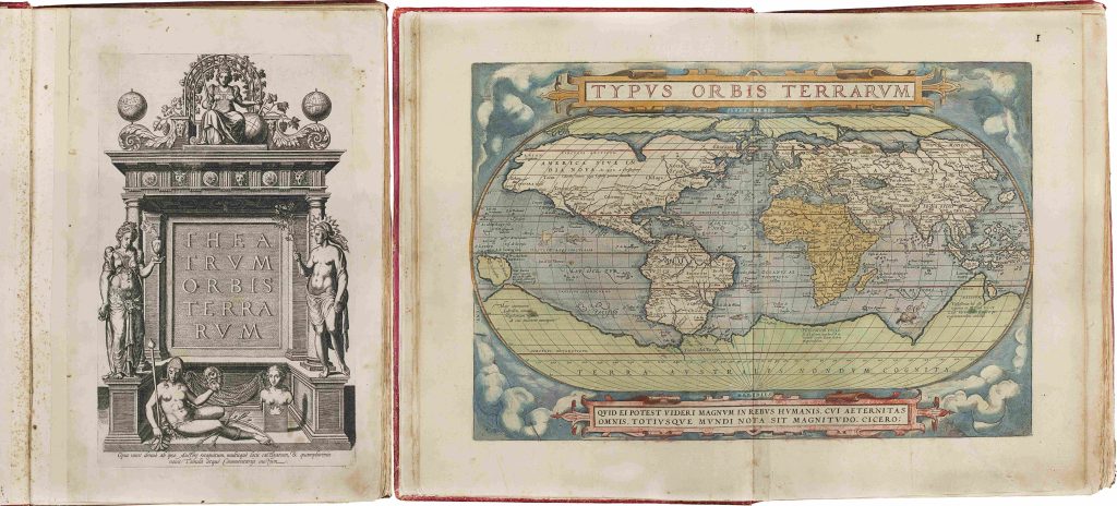
Abraham Ortelius was a Flemish cartographer, editor, and antiquarian whose Theatrum orbis terrarum, first published in Latin in Antwerp in May 1570 by Gielis Coppens van Diest, became the defining printed atlas of the later sixteenth century. The Theatrum brought together maps of the world and its regions in a uniform format, accompanied by explanatory text and source references. More than a collection of maps, it was an ordered geographical book designed to be read, consulted, compared, and expanded.
The first edition contained fifty-three map sheets. The atlas was quickly reissued, enlarged, and translated, with Dutch, French, German, Spanish, Italian, and English editions appearing over its long publication history. This copy is the 1584 French edition, part of the French-language circulation that helped extend Ortelius’s atlas beyond its original Latin scholarly audience. The opening of the atlas is especially revealing. The engraved title page presents geography allegorically through the figures of Europe, Asia, Africa, America, and the speculative southern continent, Magellanica. The facing world map, Typus orbis terrarum, translates that symbolic world order into cartographic form. Together, the two opening images establish the intellectual programme of the Theatrum: the world is staged, ordered, and made available for comparison.
The atlas was regularly revised through successive editions and through the Additamenta, which added new maps as geographical knowledge and Ortelius’s source network expanded. From 1579, Ortelius also developed the Parergon, a related series of maps devoted to ancient, classical, and biblical geography, later issued as an atlas of ancient geography in 1595. This broader project shows that Ortelius’s work was concerned not only with contemporary geography, but also with historical, scriptural, and humanist learning.
Within the collection, this atlas is the central Ortelius reference work. Individual Ortelius maps represented separately include Typus orbis terrarum (81), Indiae Orientalis, Insularumque Adiacientium Typus (106), Maris Pacifici (221and 118), Erythraei sive Rubri Maris Periplus (201), and Geographia sacra (205). The later 1603 Vrients title page (384) shows the continuation of the Theatrum after Ortelius’s death. Together, these works demonstrate the breadth of Ortelius’s project: world geography, Asian and Pacific mapping, biblical and classical geography, and the repeated visualisation of the unknown southern continent.
Ortelius, Abraham (1527–1598)
Theatrum orbis Terrarum, Antwerp: Gielis Coppens van Diest, 1570
1584, French edition
Copperplate engraving
252
R2 Very rare - one or two copies appear on the market