
Maris Pacifici, quod vulgo Mar del Zur, cum regionibus circumiacentibus, insulisque in eodem passim sparsis, novissima descriptio
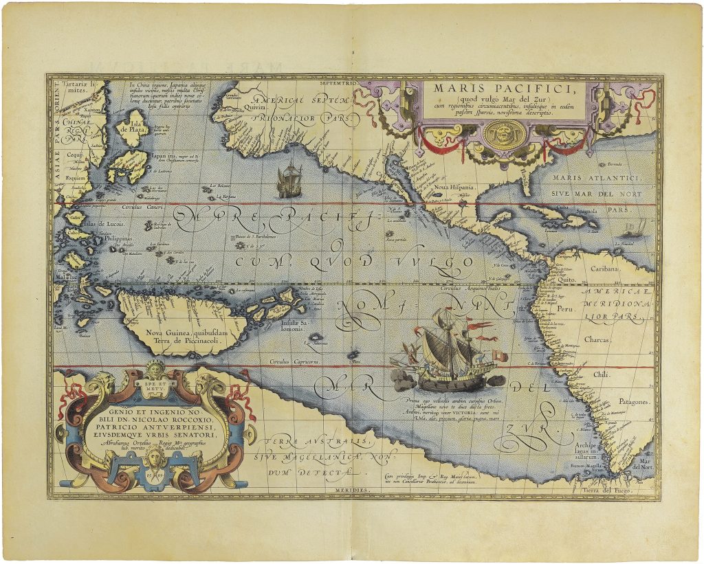
Abraham Ortelius was a Flemish cartographer, editor, and antiquarian whose Theatrum orbis terrarum, first published in Antwerp in 1570, became the defining printed atlas of the later sixteenth century (252for the 1584 edition). This map was prepared in 1589 and first appeared in the atlas with Additamentum IV in 1590. It was among the earliest printed maps to make the Pacific Ocean itself the subject of the map, rather than treating it as a secondary space beside Asia or the Americas.
The map stretches from China, Japan, the Philippines, the Moluccas, and New Guinea in the west to the coasts of North and South America in the east. Its central subject is the Mare Pacificum, the ocean Ferdinand Magellan had crossed in 1520–21. Ortelius’s title also preserves the Spanish name Mar del Zur, the “South Sea, ” first applied from the American side of the ocean after Vasco Núñez de Balboa’s sighting of the Pacific from the Isthmus of Panama in 1513. The west side of the map shows China, Japan, the Philippines, and the East Indies. Japan is represented in a large and unusual form, while the Philippines and Moluccas appear near the western edge of the Pacific, linking the map to Iberian expansion and the spice trade. New Guinea is labelled Nova Guinea, quibusdam Terra de Piccinacoli, preserving uncertainty about its identity and extent. The Solomon Islands, recently reported by Spanish voyagers, appear east of New Guinea, adding contemporary exploratory geography to the map. The American coasts are equally important. North America is labelled Americae Septentrionalior pars, with Quivira and other speculative regions appearing prominently. Central America, New Spain, Peru, Chile, Patagonia, the Strait of Magellan, and Tierra del Fuego define the eastern and southeastern edges of the ocean. The map thus frames the Pacific as an immense space between Spanish America and maritime Asia.
Across the lower part of the map runs the northern coast of Terra Australis sive Magellanica, nondum detecta — “Southern Land, or Magellanica, not yet discovered.” This phrase is central to the map’s meaning. Ortelius gives the southern continent a coastline, a name, and a position in relation to the Pacific, while also acknowledging that it remained unknown. The result is a map that makes speculative geography visually compelling without claiming empirical certainty. The large ship at lower right refers to Magellan’s circumnavigation and the return of the Victoria, the only vessel of the expedition to complete the voyage. The Latin verse beneath the ship celebrates the first ship to sail around the world and return laden with cloves, linking the Pacific to navigation, imperial ambition, maritime risk, and the spice trade. The dedication cartouche at lower left honours Nicolaas Rockox, an Antwerp patrician and later mayor, placing the map within Ortelius’s civic and humanist networks. Maris Pacifici belongs to a closely related group of late sixteenth-century maps that helped define European ideas of the Pacific and the Americas. Richard Casten and Thomas Suárez have argued that Frans Hogenberg’s Americae et proximarum regionum orae descriptio (130) was probably the earliest of this group of Pacific and American maps, followed by Giovanni Battista Mazza’s related map (219) and then Ortelius’s Maris Pacifici. Whether or not the exact sequence can be fixed with certainty, the relationship is important: all three maps show the late sixteenth-century effort to understand the Americas within a wider Pacific world, linking Spanish America, Asia, New Guinea, the Moluccas, the Solomon Islands, and the northern edge of Terra Australis.
Within the collection, this map should also be read alongside the later Spanish issue of Maris Pacifici (118), Ortelius’s world map Typus orbis terrarum (81), and his Indiae Orientalis, Insularumque Adiacientium Typus (106), where New Guinea, Beach, and the East Indies appear in a different regional configuration.
Ortelius, Abraham (1527–1598)
Theatrum orbis terrarum, Additamentum IV, Antwerp: Officina Plantiniana, 1590.
1589-dated plate; first atlas issue, 1590
Copperplate engraving
221
R2 Very rare - one or two copies appear on the market