
Geographica sacra
Abraham Ortelius was a Flemish cartographer, editor, and antiquarian whose Theatrum orbis terrarum, first published in Antwerp in 1570, became the defining printed atlas of the later sixteenth century. From 1579, he also developed the Parergon, a supplementary series of maps devoted to ancient, classical, and biblical geography, later expanded and issued as an atlas of ancient geography in 1595. Geographia sacra was engraved in 1598 and belongs to this Parergon project.
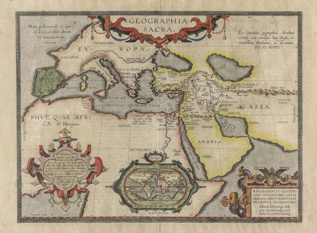
The map reconstructs the biblical world rather than the geography of contemporary exploration. It shows Europe, Asia, and Africa around the Mediterranean, Near East, Arabia, Egypt, the Red Sea, and adjoining regions, but its authority lies in scripture, genealogy, patristic interpretation, and sacred history rather than modern travel reports. Africa is labelled Phut, quae Africa D. Hieronymo, identifying it with Phut, a descendant of Ham in biblical ethnography, following Saint Jerome. The Holy Land and neighbouring regions are treated with particular density, while more distant areas are represented more schematically. This unevenness is deliberate. This unevenness is deliberate: the map is not a modern survey of the Old World, but a visual reconstruction of sacred history. At upper left, Ortelius quotes from Genesis: Mare positum est in spatioso loco, ut esset altum et immensum — a reference to the sea placed in a broad space, deep and immense. At the centre top, the title Geographia sacra is held in an ornamental cartouche. At upper right, the plate is dated 1598 and records that it was made from Ortelius’s geographical work, with royal and Brabant privileges. The lower left cartouche discusses Ophir, the biblical land associated with gold and the wealth of Solomon. Ortelius explains that because the Ophir region could not be contained within the main map, he has included a separate universal map below to show where different writers had placed it. This gives the sheet a strongly scholarly character: it is not merely illustrating scripture but comparing learned opinions about a disputed biblical location.
The small inset world map below the main image is particularly important. It is framed by the phrase from Psalm 24, Domini est terra et plenitudo orbis terrarum et universi qui habitant in eo — “The earth is the Lord’s, and the fullness thereof, the world and all who dwell in it.” Within this miniature world map, Ortelius includes polar lands labelled Hyperborea in the north and Hypernotia in the south, connecting sacred geography with older classical and cosmographical ideas about lands at the extremes of the earth. The southern polar land, Hypernotia, makes the map relevant to the collection’s southern-continent works. It is not the same as Ortelius’s Terra Australis nondum cognita (81) or Terra Australis sive Magellanica shown on his Pacific map (221and 118) but it shows another way Ortelius gave form to an imagined far south, here within a biblical discussion of Ophir. The dedication cartouche at lower right addresses Guilelmus Grimbergen, Bishop of Antwerp, placing the map within the religious and scholarly world of late sixteenth-century Antwerp.
Within the collection, this map is closely connected with Ortelius’s Erythraei sive Rubri Maris Periplus (201), another Parergon map that uses ancient textual authority to reconstruct geography.
Ortelius, Abraham (1527–1598)
Theatrum orbis Terrarum, with Parergon, Antwerp: Jan Baptist Vrients, 1598
1598, first
Copperplate engraving
205