
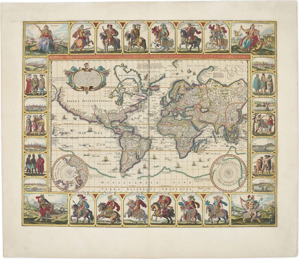
Nova totius terrarum orbis geographica ac hydrographica tabula
Claes Jansz. Visscher was an Amsterdam engraver, publisher, and map seller whose firm became one of the important Dutch map publishing houses of the first half of the seventeenth century. In 1611 he established his publishing house on the Kalverstraat, close to leading contemporaries such as Pieter van den Keere and Jodocus Hondius I. The firm was continued by his son Nicolaes Visscher I and later by his grandson Nicolaes Visscher II.
This large world map, drawn on Mercator projection, was first issued in 1637 as a separate publication in Amsterdam in 1637 and reissued in several later states. This example is the seventh state, published in 1652, the final year of Claes Jansz. Visscher’s life. Known as the “Twelve Caesars” map, it is one of the most ambitious decorative world maps of the Dutch Golden Age. The upper and lower borders are filled with mounted Roman emperors derived from prints by Antonio Tempesta, while the corners contain allegorical figures of the four continents after designs by Adriaen Collaert and Maerten de Vos. The geography presents a world still being tested against exploration. Tierra del Fuego is shown as a distinct landmass, no longer ajoined to the southern continent, yet a vast Magellanica sive Terra Australis Incognita still occupies the lower part of the map. California appears as an island, one of the most persistent cartographic misconceptions of the seventeenth century. Two polar hemispheres are placed along the lower edge within the southern landmass, which is broken south of South America and near New Guinea. The large cartouche in North America contains a Latin inscription recounting the discovery of America and the history of circumnavigation. It refers to Christopher Columbus and Amerigo Vespucci, and also to Francis Drake, Olivier van Noort, Sebald de Weert, Joris van Spilbergen, and Jacob le Maire, placing Dutch navigators within a broader genealogy of global exploration.
The map’s border turns geography into spectacle. The upper border presents Iulius Caesar, Augustus, Tiberius, Caligula, Claudius, Nero, and Asia; the lower border shows Africa, Galba, Otho, Vitellius, Vespasianus, Titus, Domitianus, and America. The side borders alternate between costumed peoples and city views: on the left, Roma, Europaei, Amsterdam, Asiatici, Ierusalem, Africani, and Tunis; on the right, Mexico, Americani Sept., Havana, Americani Merid., Parnambuco, Magellanici, and B. de Todos Santos. The gold heightening in this seventh state emphasises the map’s decorative and ceremonial character. The border does more than embellish the sheet: through classical rulers, personifications of the continents, explorers, peoples, and cities, it presents Dutch world geography within a framework of classical learning, global travel, and commercial reach.
Within the collection, this map is closely connected with Claes Jansz. Visscher’s smaller 1649 world maps (292and 293), where older southern-continent geography is revised to include Dutch discoveries in New Holland and Van Diemen’s Land. It also relates to Nicolaes Visscher I’s later world maps (25, 93, 129, and 287), which show the next phase of Visscher-family world cartography after Tasman. Pieter Verbiest’s world map (313) provides a useful Antwerp comparison for the persistence of Terra Australis nondum cognita in early seventeenth-century world mapping.
Visscher, Claes Jansz. (1587–1652)
Separate publication. Amsterdam: Claes Jansz. Visscher, 1637
1652, Seventh
1639, second; 1640, third; 1646, fourth; 1648, fifth; 1649, Sixth
Copperplate engraving
458
R2 Very rare - one or two copies appear on the market