
Sphera in plano
Lorenz Fries was a Strasbourg physician, astrologer, and editor whose 1522 edition of Ptolemy’s Geographia reworked the maps and diagrams associated with Martin Waldseemüller’s earlier Strasbourg editions. In 1522, Johann Grüninger acquired the woodblocks used for Waldseemüller’s maps from Johann Schott and commissioned Fries to prepare a new, smaller-format edition. Fries reduced and simplified the earlier maps and diagrams while also adding material intended to reflect more recent geographical knowledge.
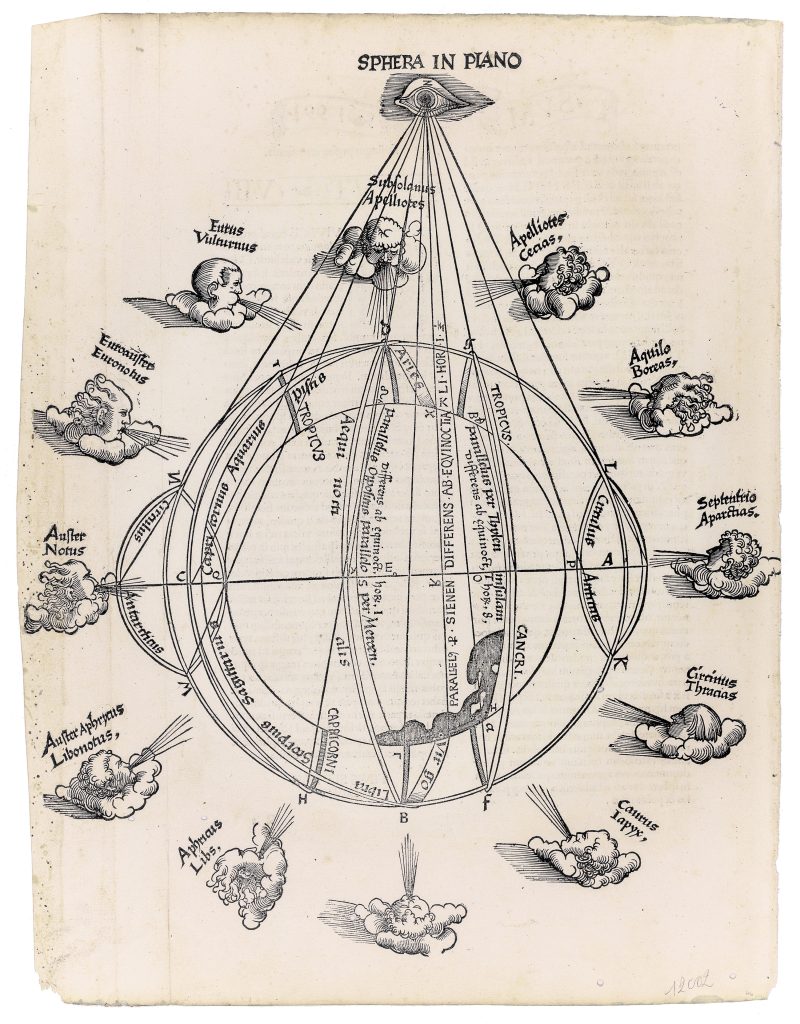
Martin Waldseemüller’s Sphera in plano, or “sphere in a plane, ” first published in 1513 and again in 1520 as part of his Geographia, presents a schematic diagram of the world within an armillary sphere. The diagram illustrates the earth’s place within the celestial sphere, using the North and South Poles as reference points and incorporating celestial elements including zodiac constellations and cardinal winds. Fries’s version of Sphera in plano accompanies Book Seven, chapter six, of the 1522 Geographia, in a section titled Circularis sphaerae cum habitabili terra descriptio — "Description of a circular sphere with the habitable earth." This placement shows that the diagram was intended as an explanatory image, helping readers understand the earth’s position within a larger celestial and geometrical framework.
The diagram positions the viewer’s eye in relation to the globe, which is centred at point E and enclosed within the armillary ring marked ABCD. The imagined North Pole is marked as point A, while the South Pole is designated as point C. Terrestrial features include the Tropics of Cancer and Capricorn and the Equator, whose extremities are shaded to indicate their passage beyond the viewer’s field of vision. Celestial elements are also included. The zodiac signs Libra, Scorpio, Sagittarius, Capricorn, Aquarius, and Pisces appear around the sphere, while the cardinal winds are labelled around the outer edge. The North wind, Septentrio and Aparctias, appears to the right; the South wind, Auster and Notus, appears to the left; and the East wind, Subsolanus and Apelliotes appears at the top. The West is not named in Fries’s version, which marks a difference from Waldseemüller’s earlier diagram.
Within the collection, this diagram is closely connected with Fries’s world maps (70, 89, and 359), which translate cosmographical and geographical ideas into mapped form. It is also useful to compare it with the Dürer-attributed Armillary Sphere (333), issued in the 1525 Strasbourg edition of Ptolemy’s Geographia. Together, these works show how Renaissance geographical books used diagrams as well as maps to explain the structure of the earth and heavens.
Fries, Lorenz (c. 1490–1532)
Ptolemy, Geographia, ed. Lorenz Fries, Strasbourg: Johann Grüninger, 1522
1522, first
Woodcut
3
R1 Extremely rare - occasionally seen on the market