
Typus orbis descriptione Ptolemaei
Lorenz Fries was a Strasbourg physician, astrologer, and editor whose cartographic work was closely tied to the maps first published in Martin Waldseemüller’s 1513 Strasbourg edition of Ptolemy’s Geographia. His 1522 edition of Ptolemy’s Geographia, printed by Johann Grüninger, reused and reduced the maps first published in Martin Waldseemüller’s 1513 Strasbourg edition. After Grüninger's death around 1531, his son Christoph continued the business and ultimately sold the Geographia materials to the Lyon-based publishers Melchior and Gaspar Trechsel, who issued editions in 1535 and 1541.
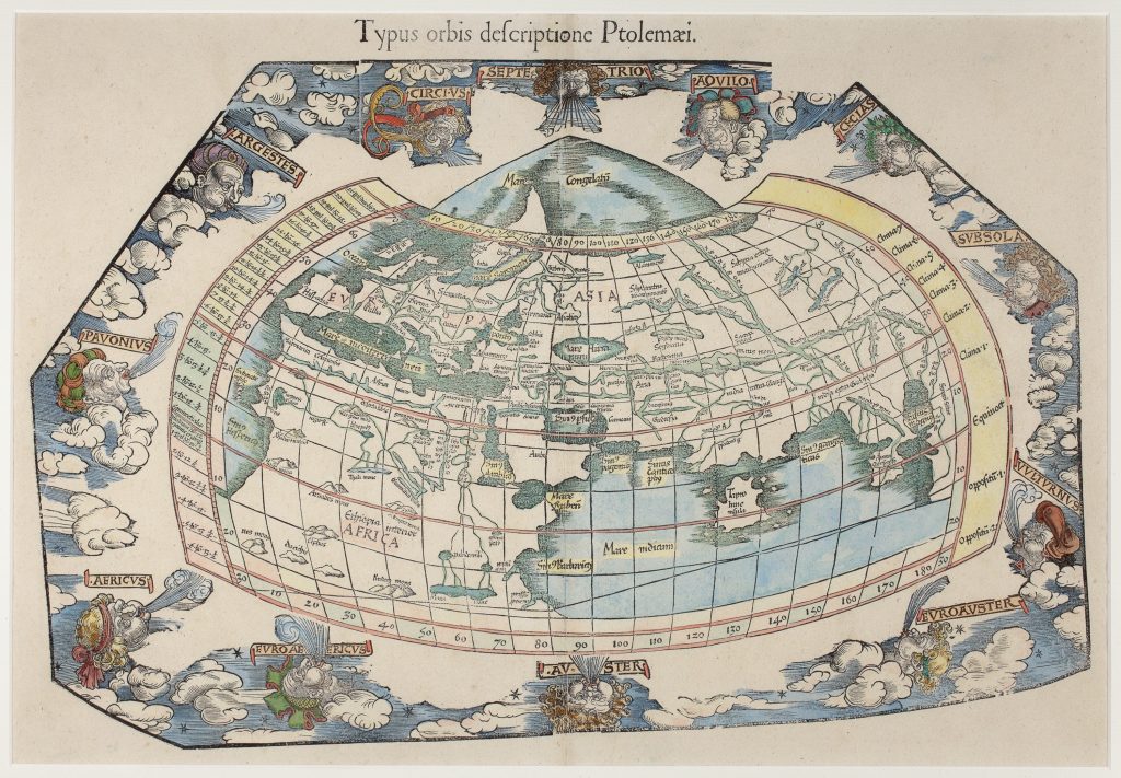
This Ptolemaic world map presents the world according to Ptolemy’s classical geography. It is identifiable as the later state described by Rodney Shirley, with the title Typus orbis descriptione Ptolemaei and a missing segment from the top right-hand corner of the block. It is recorded here as the 1541 fourth edition of Fries’s Geographia. Although Fries’s atlas also included modern maps based on newer hydrographic knowledge, this map preserved the ancient geographical framework against which those modern maps could be compared. The map shows the inhabited world across 180 degrees of longitude using Ptolemy’s second projection. Europe, Africa, and Asia are contained within a curved graticule, while the Indian Ocean is shown as an enclosed basin. Africa extends only as far south as the Tropic of Capricorn, and the geography east of the Indian Ocean reflects classical rather than modern voyage-based knowledge. The result is a compact image of the ancient world as it continued to be transmitted in Renaissance editions of Ptolemy.
The source of the Nile is depicted as a mountain range labelled Montes Lunae, or Moon Mountains. In keeping with Ptolemaic tradition, the river is shown originating from snowmelt in these mountains and flowing northward into two lakes labelled Paludes and Nili. The Indian Ocean appears as an enclosed sea, though the landmass traditionally connecting southern Africa to Asia is absent. Surrounding the map are twelve wind-heads, blowing from the cardinal and intermediate directions. These winds give the map a cosmographical frame, linking terrestrial geography with the classical ordering of the atmosphere and heavens.
Within the collection, this Ptolemaic world map should be read against Fries’s modern world maps (89and 359), which explicitly show how the world known to hydrographers differed from the world described by Ptolemy. It also relates to Fine’s double cordiform world map (88) and Eckebrecht’s later world map associated with Kepler’s Tabulae Rudolphinae (125), both of which use projection and cosmographical structure to present changing ideas of the world.
Fries, Lorenz (c. 1490–1532)
Ptolemy, Geographia, ed. Lorenz Fries, Strasbourg: Johann Grüninger, 1522
1541, fourth with title and missing top-right segment
1525, second: Strasbourg; 1535, third: Lyon
Woodcut
70
R4 Common - often seen on the market