
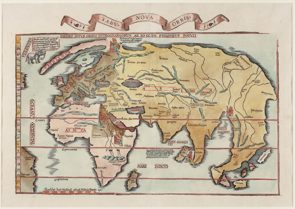
Tabu nova orbis / Differt situs orbis hydrographorum ab eo quem Ptolomeus posuit
Lorenz Fries was a Strasbourg physician, astrologer, and editor whose 1522 edition of Ptolemy’s Geographia reworked the maps associated with Martin Waldseemüller’s earlier Strasbourg editions. In 1522, Johann Grüninger acquired the woodblocks used for Waldseemüller’s maps from Johann Schott and commissioned Fries to prepare a smaller-format edition. Fries reduced and simplified many of the earlier maps, while also adding or adapting maps that reflected more recent geographical knowledge.
This modern world map, titled Tabula nova orbis / Differt situs orbis hydrographorum ab eo quem Ptolomeus posuit, makes that contrast explicit. Its title states that the world described by hydrographers differs from the world set out by Ptolemy. It should therefore be read against Fries’s Ptolemaic world map, Typus orbis descriptione Ptolemaei (70), which preserves the classical geographical framework. This map should also be distinguished from Fries’s other modern world map, Orbis typus universalis iuxta hydrographorum traditionem exactissime depicta (359). That map bears Fries’s initials and the date 1522 and uses a more explicitly nautical visual language of criss-cross directional lines and wind banners. By contrast, this map removes those directional lines and instead frames the modern world through explanatory inscriptions, enthroned rulers, and natural-historical imagery. The geography is simplified and selective. Only a small, unnamed part of South America is shown, marked by Caput S. Anas and Terra Papagalli. The Caribbean islands Spagnolla and Isabella, which appear on Fries’s other modern world map (359), are omitted here. The map therefore does not simply duplicate 359, but offers a different version of modern geography within the same atlas tradition.
Fries’s adaptation also includes five enthroned rulers. The northernmost figure, near Moscovia, represents the ruler of Russia and is the only European sovereign depicted. The accompanying inscription identifies him as: "the great prince and Emperor of Russia and Moscow, the king of Polodia and Plescovia." Other rulers appear in Africa, associated with Egypt and Ethiopia, and in Asia, near Taprobane and Mursuli. These figures present geography as a political as well as spatial order, linking regions of the world to named rulers and territories. In the northwest corner, near the elongated peninsula labelled Gronlanda, Fries included an elephant-like animal apparently intended to represent a walrus. The accompanying inscription describes the walrus as a huge northern animal, the size of an elephant, with two long quadrangular teeth and no joints in its legs. This curious image shows how early sixteenth-century world maps combined geography with natural history, travel report, and inherited marvel traditions. Another inscription near Taprobane discusses competing ancient authorities concerning the island’s latitude and then compares them with Portuguese voyage evidence: Ptolemy unambiguously indicates that Taprobana is located on the equator, while Solinus shows otherwise, as the northern stars cannot be seen there, and the Pleiades can never appear there. The moon is only above the horizon there from the eighth to the sixteenth day of the month, and the Portuguese voyages in this area unambiguously confirm this.” This passage is one of the map’s most revealing features. It shows Fries using recent maritime information not simply to replace ancient authority, but to test, correct, and compare it.
This example comes from the 1535 Trechsel edition and is notable for the decorative title scroll above the map. Within the collection, it should be read alongside Fries’s Ptolemaic world map (70) and his other modern world map (359). Together, these maps show how Fries’s Geographia presented classical and modern geography side by side, allowing readers to compare Ptolemy’s inherited world with the newer geography of hydrographers, navigators, and printed travel knowledge.
Fries, Lorenz (c. 1490–1532)
Ptolemy, Geographia, ed. Lorenz Fries, Strasbourg: Johann Grüninger, 1522
1535, third
1525, second: Strasbourg; 1541, fourth: Vienne
Woodcut
89
R2 Very rare - one or two copies appear on the market