
Batavia assiegé en 1629. / Batavia A° 1629 Belegerd
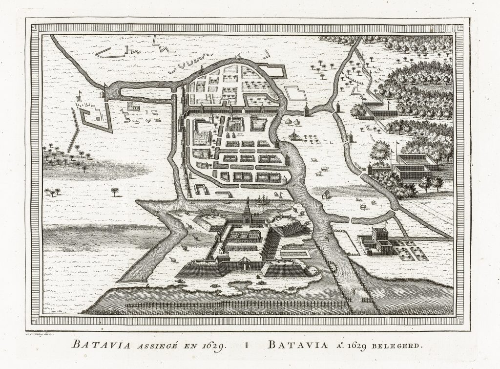
Jacobus van der Schley was a Dutch engraver and draughtsman active in Amsterdam in the mid-eighteenth century. He engraved maps, plans, views, and illustrations for historical and geographical publications, often adapting earlier material for new printed contexts. This engraved plan-view of Batavia shows the city during the 1629 siege by the forces of the Mataram Sultanate.
The bilingual French and Dutch title identifies the scene as a retrospective image of Batavia under siege. The city is shown as a fortified Dutch settlement on the north coast of Java, with canals, walls, bastions, gates, streets, and surrounding defensive works. The plan also shows the river, nearby settlements, fields, trees, and military positions outside the walls, presenting Batavia as both a fortified town and a colonial foothold within a wider Javanese landscape. The siege of 1629 was one of the major early challenges to Dutch power at Batavia. The Mataram Sultanate, under Sultan Agung, attempted to dislodge the Dutch East India Company from its newly established headquarters. Although the attack failed, the siege became an important episode in Dutch accounts of the Company’s consolidation in Java.
This plate was engraved more than a century after the event. It should therefore be read not as an eyewitness record, but as an eighteenth-century historical reconstruction of an episode central to Dutch colonial memory. Its value lies in the way it visualises Batavia’s early vulnerability: the fortified city, the surrounding water systems, and the military pressure from Javanese forces are all brought together in a compact explanatory image.
Within the collection, this view is closely connected with Schley’s Carte des environs de Batavia / Kaart van de buitenstreeken van Batavia (188), which shows Batavia’s surrounding district in a later eighteenth-century cartographic form. It also relates to other Batavia and Java-related material, including Petrus Schenk’s Bantam, een stadt gelegen op het eiland Java, beroemt door den Koophandel (141), Jan van Ryne’s Perspective view of Batavia (184), the later Paris optical version of Batavia (197), Georg Balthasar Probst’s De Reede van Batavia (475), and Sayer and Bennett’s Plan of the Road and City of Batavia (298), and Het Eiland Onrust, naby Batavia (185), which shows the maritime infrastructure supporting Batavia’s later role as the principal Dutch centre in Asia.
Schley, Jacobus van der (1715–1779)
Prévost, Antoine-François, Histoire générale des voyages, Paris: Didot, 1746–1770
c. 1760, bilingual Dutch/French issue
Copperplate engraving
186