
Typus orbis terrarum
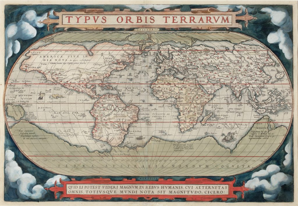
Abraham Ortelius was a Flemish cartographer, editor, and antiquarian whose Theatrum orbis terrarum, first published in Antwerp in 1570, became the defining printed atlas of the later sixteenth century (252for the 1584 edition). Typus orbis terrarum is the opening world map of the atlas and gives visual form to the Theatrum’s central ambition: to present the known world in a coherent, portable, and scholarly printed format.
The map is engraved on an oval projection and framed by clouds, with a large title cartouche above and a quotation from Cicero below: “What can seem great in human affairs to one who has all eternity and the whole extent of the world before his eyes?” The quotation is not merely decorative. It situates geography within a humanist moral framework, inviting the viewer to contemplate the world from a detached, philosophical perspective. This example belongs to the first plate of Ortelius’s world map, signed by Frans Hogenberg and used from the first edition of the Theatrum in 1570 until the mid-1580s. Around 1575, a crack appeared in the lower-left corner of the plate. In the second state, bolt impressions were added as a temporary repair. A third state, dating from around 1579, shows partial repair of the crack and reworking of the surrounding clouds. In the fourth state, produced in 1584, the date “1584” was added to Hogenberg’s signature. A final, fifth state, dated 1585, completed the revisions to the first plate before it was replaced. Ortelius’s map is closely derived from Gerard Mercator’s large wall map of 1569, but it transforms Mercator’s complex wall-map geography into the more compact format of the printed atlas. Europe, Africa, Asia, and the Americas are shown within a single global image, while the projection gives the map a balanced, theatrical quality suited to the opening of the Theatrum. The map retains several of Mercator’s uncertainties, including the exaggerated bulge on the west coast of South America and the uncertain configuration of the far northern and northwestern parts of America.
The southern hemisphere is dominated by Terra Australis nondum cognita, the “southern land not yet known.” This large hypothetical landmass reflects the enduring sixteenth-century belief that a southern continent was needed to balance the landmasses of the northern hemisphere. Ortelius labels several inherited or misplaced southern names, including Beach, Lucach, and Maletur, which came from European readings of Marco Polo and related travel traditions. Their placement on the northern edge of the southern continent shows how textual authority, geographical speculation, and cartographic design combined to make Terra Australis appear plausible. New Guinea is shown as an island-like landmass but is accompanied by a note indicating uncertainty about whether it might belong to the southern continent. This ambiguity is important. Ortelius’s world map does not simply assert knowledge; it maps the limits of knowledge. It allows speculative geography to remain visible while marking some regions as The map’s imagery and inscriptions also connect it closely to the allegorical title page of the Theatrum. Where the title page personifies Magellanica as an incomplete female bust, this map gives the same speculative geography a broad cartographic form. The two opening images of the atlas therefore work together: one allegorical, one geographical, both presenting the southern continent as a powerful but uncertain presence.
Within the collection, this map relates closely to Ortelius’s Indiae Orientalis, Insularumque Adiacientium Typus (106), where ~Beach ~and New Guinea appear in regional context, and to Maris Pacifici (221and 118), where the northern coast of Terra Australis sive Magellanica is developed in relation to the Pacific. Together these works show how Ortelius repeatedly returned to the problem of the southern continent across world, regional, and oceanic mapping.
Ortelius, Abraham (1527–1598)
Theatrum orbis Terrarum, Antwerp: Gielis Coppens van Diest, 1570
1570, first
Copperplate engraving
81
R2 Very rare - one or two copies appear on the market