
Nova totius terrarum orbis geographica ac hydrographica tabula
Henricus Hondius was the younger son of Jodocus Hondius I and a central figure in the continuation of the Mercator-Hondius atlas business in Amsterdam. After Jodocus Hondius I’s death in 1612, Henricus and his brother Jodocus Hondius II continued the family publishing house. In 1629, after Jodocus II’s death, thirty-seven Mercator-Hondius copperplates were sold to their competitor Willem Jansz. Blaeu. Blaeu altered these plates and incorporated them into his own atlas, Atlantis appendix sive pars altera, published in 1630. In response, Henricus partnered with his brother-in-law Johannes Janssonius, commissioned replacement plates, and issued the rival Atlantis maioris appendix, sive pars altera in the same year. This competition between the Hondius-Janssonius and Blaeu publishing houses shaped Dutch atlas production for decades.
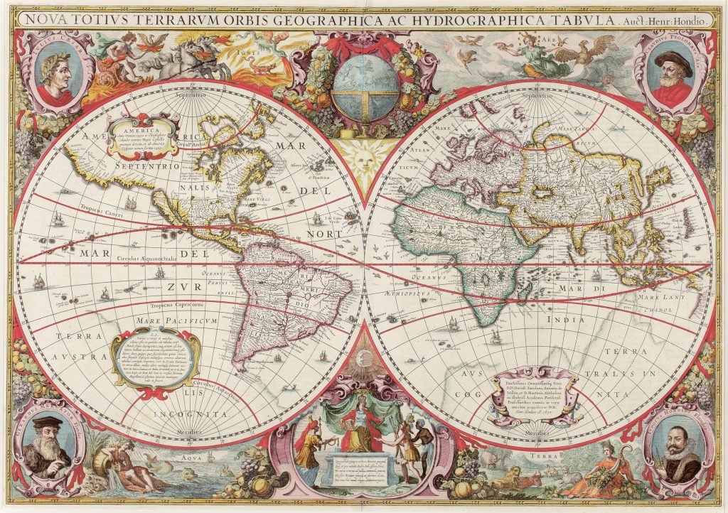
This double-hemisphere world map was first published in the 1630 Atlantis maioris appendix, sive pars altera. It was one of the new plates produced after the sale of earlier Mercator-Hondius plates to Blaeu. This example is the first state, dated 1630. The map is notable for combining inherited world geography with recent Dutch discoveries. It retains a faint representation of Terra Australis Incognita, with Beach appearing on a promontory south of Java, a name derived ultimately from Marco Polo and long misplaced by European cartographers onto the northern edge of the imagined southern continent. At the same time, the map includes an early printed representation of Australia’s northern coastline extending toward New Guinea. This northern Australian geography reflects Dutch exploration after Willem Jansz.’s 1606 voyage in the Duyfken. Jansz. charted part of the western side of Cape York Peninsula and the Gulf of Carpentaria but did not recognise Torres Strait, treating the coast as an extension of New Guinea. The name Keerweer, meaning “turn back, ” marks the place where Jansz. decided to return to Java. The map also incorporates information from Jan Carstensz.’s 1623 expedition to the Gulf of Carpentaria, including names such as Valsche Caep and Hooghe land.
The decorative programme is part of the map’s meaning. The two hemispheres are surrounded by personifications of the four elements and other scenes. The upper corners contain portraits of Julius Caesar and Claudius Ptolemy, while the lower corners show Gerard Mercator and Jodocus Hondius I, Henricus’s father. The design presents world geography as part of a lineage joining classical authority, Mercatorian cartography, and the Hondius-Janssonius atlas tradition. Rodney Shirley and van der Krogt record four states of the plate. The first state is this 1630 issue. The second state, dated 1641, adds Amstelodami Excudit Ioannes Ianssonius at the bottom. The third state, dated 1663 and represented in the collection by 123, appeared in Jan Jansson’s Atlas Contractus and in Van Loon’s sea atlases. The fourth state, dated 1666 and represented by 126, appeared in Jansson’s Atlas Major. Comparing 82, 123, and 126shows how the map was reused and updated over time while retaining its ornate double-hemisphere design.
Within the collection, this map should be compared with Willem Jansz. Blaeu’s 1606 world map (9) and Joan Blaeu’s later Nova et accuratissima totius terrarum orbis tabula (30and 75). It also relates to Jodocus Hondius I’s world map (199), Abraham Ortelius’s world map (81), and Polus Antarcticus (114and 18). Together, these works show how inherited of Terra Australis were gradually combined with new Dutch information from Australia and the Pacific.
Hondius, Henricus (1597–1651)
Atlantis maioris appendix, sive pars altera, Amsterdam: Henricus Hondius, 1630
1630, first
Copperplate engraving
82
R4 Common - often seen on the market