
Iava Maior
Claes Jansz. Visscher was an Amsterdam engraver, publisher, and map seller whose firm became one of the important Dutch map publishing houses of the first half of the seventeenth century. In 1611 he established his publishing house on the Kalverstraat, close to leading contemporaries such as Pieter van den Keere and Jodocus Hondius I. The firm was continued by his son Nicolaes Visscher I and later by his grandson Nicolaes Visscher II.
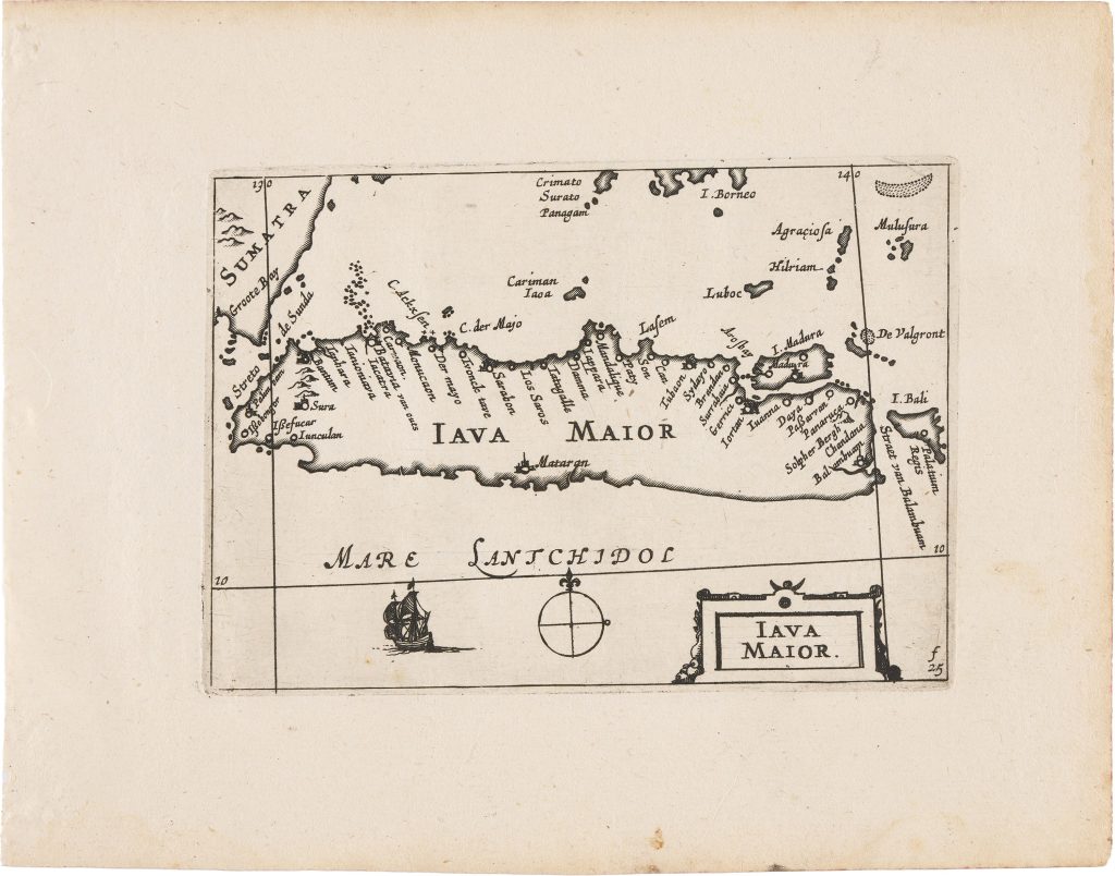
Following the death of Cornelis Claesz. in 1612, the copperplates for Barent Langenes’s Caert-thresoor of 1598 passed through several hands before being acquired by Visscher. In 1649 he reissued and expanded this material as Tabularum geographicarum contractarum libri quatuor denuo recogniti, a compact atlas divided into four parts: Europae, Asiae, Africae, and Americae. the copperplates for Barent Langenes’s Caert-thresoor(1598) (#~294, ~295, 296, 383, 388) passed through several hands before being acquired by Visscher. In 1649, he reissued and expanded this material as Tabularum geographicarum contractarum libri quatuor denuo recogniti, a compact atlas divided into four parts: Europae, Asiae, Africae, and Americae nova descriptio. Alongside the inherited Caert-thresoor plates, the 1649 edition included twenty-three newly engraved maps, among them ’t Landt van de Eendracht (12), Anthoni van Diemens Landt (11), and this map of Iava Maior, as well as several plates engraved by Benjamin Wright (369, 370). The atlas also includes two revised world maps, Typus Orbis Terrarum (292) and Iehova (293) both originally engraved by Jodocus Hondius I for Langenes’s 1598 Caert-Thresoor (294and 296).
In this revised state, Visscher depicts the island of Java, or Iava Maior in its entirety, together with portions of Sumatra to the west and Bali and Lombok to the east. Coastal place names are densely distributed, especially along the northern shore, reflecting the island’s importance within Dutch commercial and navigational networks during the period of VOC expansion. The surrounding sea is labelled Mare Lantchidol a name used in Dutch mapping of the East Indies and the Southland. Decorative elements are restrained, consisting of a simple compass rose and a small ship. In the lower right corner, the marking “f.25” appears, a binder’s reference indicating the intended position of the sheet within the atlas. Within Visscher's 1649 atlas, Iava Maior functions as a regional counterpart to the more innovative plates devoted to Australia and Abel Tasman’s discoveries, including ’t Landt van de Eendracht (12) and Anthoni van Diemens Landt (11), situating Java within the broader geography of Dutch expansion in the East Indies.
Within the collection, this map is closely connected with Visscher’s related Australian maps (11and 12), which connect Java and the East Indies with Dutch knowledge of New Holland and Tasmania. It also relates to later English sea charts of the same maritime region, including John Thornton’s charts of Java, Madura, Bali, Borneo, and Celebes (398and 399), and to François Valentijn’s later Dutch account of the East Indies (177and 262).
Visscher, Claes Jansz. (1587–1652)
Tabularum geographicarum contractarum libri quatuor denuo recogniti, Amsterdam: Claes Jansz. Visscher, 1649
1649, first
Copperplate engraving
371
R1 Extremely rare - occasionally seen on the market