
Erythraei sive Rubri Maris Periplus, olim ab Arriano descriptus, nunc vero ab Abrah. Ortelio ex eodem delineatus
Abraham Ortelius was a Flemish cartographer, editor, and antiquarian whose Theatrum orbis terrarum, first published in Antwerp in 1570, became the defining printed atlas of the later sixteenth century. From 1579, Ortelius also developed the Parergon, a supplementary series of maps devoted to ancient, classical, and biblical geography. later issued more fully as a separate work in 1595. The series was expanded over subsequent editions and, in 1595, was issued as an atlas of ancient geography in its own right, though it was often bound with the Theatrum.
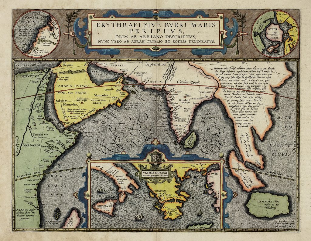
This map is based on the Periplus Maris Erythraei, an ancient navigational account of coastal ports and landmarks of the Red Sea, Arabian Sea, and Indian Ocean world. The title attributes the description to Arrian, though the text now known as the Periplus Maris Erythraei is generally treated as the work of an unknown Greek-speaking author. Ortelius’s purpose was not simply to copy ancient geography, but to bring together ancient texts, historical geography, and humanist scholarship within the format of an atlas map. The main map covers the maritime world from Egypt and the Red Sea across Arabia, Persia, India, Taprobana, and the Bay of Bengal to Southeast Asia. It includes the Erythraeum sive Rubrum Mare, the Red Sea or Erythraean Sea, a term that in ancient geography could refer not only to the modern Red Sea but more broadly to the waters of the western Indian Ocean. Arabia is divided into regions including Arabia Felix; India is shown with classical place names; and Taprobana, often associated with Sri Lanka, appears prominently. The map is therefore a learned reconstruction of ancient commercial and navigational geography rather than a modern sea chart. Ortelius enriches the sheet with three important inset maps. At upper left, Annonis Periplus represents the voyage of Hanno along the west coast of Africa, extending the theme of ancient maritime exploration beyond the Indian Ocean. At upper right, a circular northern inset shows the Hyperborei, invoking classical ideas of peoples and lands at the edge of the known world. At lower centre, Ulyssis Errores maps the wanderings of Ulysses, or Odysseus, in the Mediterranean, drawing Homeric epic into the same geographical field as ancient trade and exploration.
These insets make the sheet unusually rich. It is not only a map of the Indian Ocean; it is a comparative map of ancient voyaging. Hanno, Ulysses, and the anonymous author of the Periplus represent different kinds of geographical knowledge: exploration, epic wandering, and practical maritime description. Ortelius places them together, allowing the viewer to move between history, literature, navigation, and antiquarian scholarship. The map also reveals how Ortelius used cartography to reconcile ancient authority with the expanding geographical knowledge of his own time. The Indian Ocean was central to Portuguese and Dutch ambitions in Asia, but here it is viewed through ancient texts rather than contemporary navigation. In that sense, the map forms a counterpart to Ortelius’s modern Asian and Pacific maps: it shows the same broad world of Arabia, India, Southeast Asia, and oceanic travel, but through the lens of classical scholarship.
Within the collection, this map is closely connected with Ortelius’s Geographia sacra (205), another Parergon map that reconstructs geography through textual authority. It also complements Indiae Orientalis, Insularumque Adiacientium Typus (106), where the East Indies are mapped as a modern commercial and imperial region, and Maris Pacifici (221and 118), where Asian waters are connected to the Pacific and the Americas.
Ortelius, Abraham (1527–1598)
Theatrum orbis Terrarum, with Parergon, Antwerp: Joannes Moretus, Officina Plantina, 1601
1601, first
Copperplate engraving
201