
A new chart of the eastern coast of New Holland
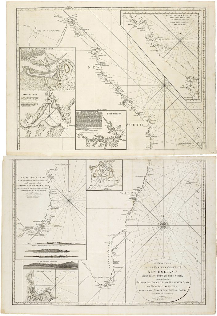
Robert Sayer was a London map, chart and print publisher whose firm issued nautical charts, atlases, and geographical works for British and international markets in the later eighteenth century. This chart of the eastern coast of New Holland was published in London by Sayer in 1787, at a moment when British interest in the Australian coast was increasing rapidly.
The chart extends from Van Diemen’s Land and the southern coast of New Holland northwards along New South Wales to Cape York, with the Gulf of Carpentaria shown at the northern edge. Its title explicitly brings together the discoveries of Abel Tasman, Tobias Furneaux, and James Cook, identifying the chart as a compilation of earlier Dutch and British coastal knowledge rather than a single survey. Cook’s east-coast charting from the Endeavour voyage is central to the chart, while Tasman and Furneaux provide the southern framework around Van Diemen’s Land.
Several insets and coastal profiles expand the chart’s practical value. These include the coast from Cape Tribulation to Endeavour Strait, showing the Labyrinth of the Great Barrier Reef on a larger scale; the entrance of Endeavour River, where Cook repaired the Endeavour after grounding on the reef in 1770; Botany Bay; Port Jackson; Sydney Cove; Adventure Bay; and a particular chart of the southernmost part of New Holland. Coastal profiles of Van Diemen’s Land, Fluted Cape, Penguin Island, the Mewstone, and Adventure Bay provided visual aids for recognising land from the sea.
Within the collection, this chart is closely connected with Cook-related material, especially the Endeavour voyage chart (38), since Sayer’s compilation depends heavily on Cook’s mapping of the east coast of New Holland. It also relates to John Septimus Roe’s later A Survey of Port Jackson, New South Wales (175and 442), where Port Jackson is mapped in much greater hydrographic detail, and to Thomas Pennant’s Map for Mr Pennants Outline of the Globe (178) and Johann Matthias Christoph Reinecke’s General Charte von Australien (26), which show the rapid revision of Australian coastal geography around 1800.
Sayer, Robert (1725–1794)
London: Robert Sayer, 1787
1787
Copperplate engraving
36
R2 Very rare - one or two copies appear on the market