
A chart of New South Wales, or the east coast of New-Holland
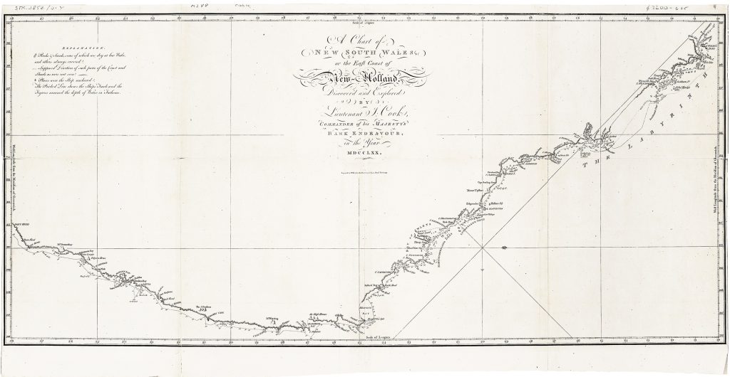
James Cook’s A Chart of New South Wales, or the East Coast of New Holland, is the first printed depiction of Australia’s east coast based on Cook’s survey during the first Pacific voyage of HMS Endeavour. Engraved by William Whitchurch, it was published in John Hawkesworth’s official account of the voyages of Commodore John Byron, Captain Samuel Wallis, Captain Philip Carteret, and Lieutenant James Cook, issued in London by W. Strahan and T. Cadell in 1773. Later versions and copies by other publishers circulated widely, but this is the official first published chart from Hawkesworth’s account.
The chart is oriented with west at the top, so that the coast runs across the sheet from Cape York and Endeavour Strait at the upper right to Point Hicks at the lower left. Cook’s coastal names trace the progress of the Endeavour northward along the eastern seaboard, including Botany Bay, Port Jackson, Broken Bay, Moreton Bay, Cape Tribulation, Endeavour River, and the passage through the reef toward Endeavour Strait. Soundings, shoals, islands, capes, and coastal profiles record the navigational work of the voyage, while the interior remains largely blank, emphasising that this was a maritime chart rather than a land map. Cook’s first voyage, undertaken between 1768 and 1771, had several purposes: to observe the transit of Venus at Tahiti, to explore the South Pacific, and to investigate the long-hypothesised southern continent. After charting New Zealand, Cook crossed the Tasman Sea and sighted the Australian coast near Point Hicks in April 1770. The Endeavour then sailed north, stopping at Botany Bay and later spending several weeks at Endeavour River after striking the Great Barrier Reef. This chart records that difficult coastal passage and translates Cook’s manuscript observations into the printed form through which European readers first encountered the east coast as New South Wales.
The chart marks a decisive moment in the printed cartography of Australia. Earlier European maps had recorded parts of the western, northern, and southern coasts from Dutch voyages, but Cook’s survey added the eastern seaboard and made possible a more continuous understanding of the continent’s outline. Published in the official account of the voyage, the chart also gave British geographical and political form to Cook’s claim of possession at Possession Island in August 1770. Its importance lies not only in the coastal information it contains, but in its role in transforming the east coast of New Holland into the mapped territory of New South Wales.
This chart is closely connected with works in the collection that record earlier Dutch knowledge of Australia, including Van Keulen’s East Indies charts (83, 95, and 266), the western Australia chart associated with Willem de Vlamingh (139), Jacob Swart’s facsimile of the Tasman/VOC composite chart (229), and Johannes de Lat’s later map of Nieu Holland (389). Together, these works contrast Dutch mapping of Australia’s western, northern, and southern coasts with Cook’s British survey of the east coast and the printed emergence of New South Wales.
Cook, James (1728–1779)
John Hawkesworth, An Account of the Voyages undertaken by the Order of His Present Majesty for making Discoveries in the Southern Hemisphere, London: W. Strahan and T. Cadell, 1773
1773, first
Later versions and copies by other publishers circulated widely, but this is the official first published chart from Hawkesworth’s account
Copperplate engraving
38
R2 Very rare - one or two copies appear on the market