
Carte réduite de la mer des Indes et de la partie occidentale du Grand Océan
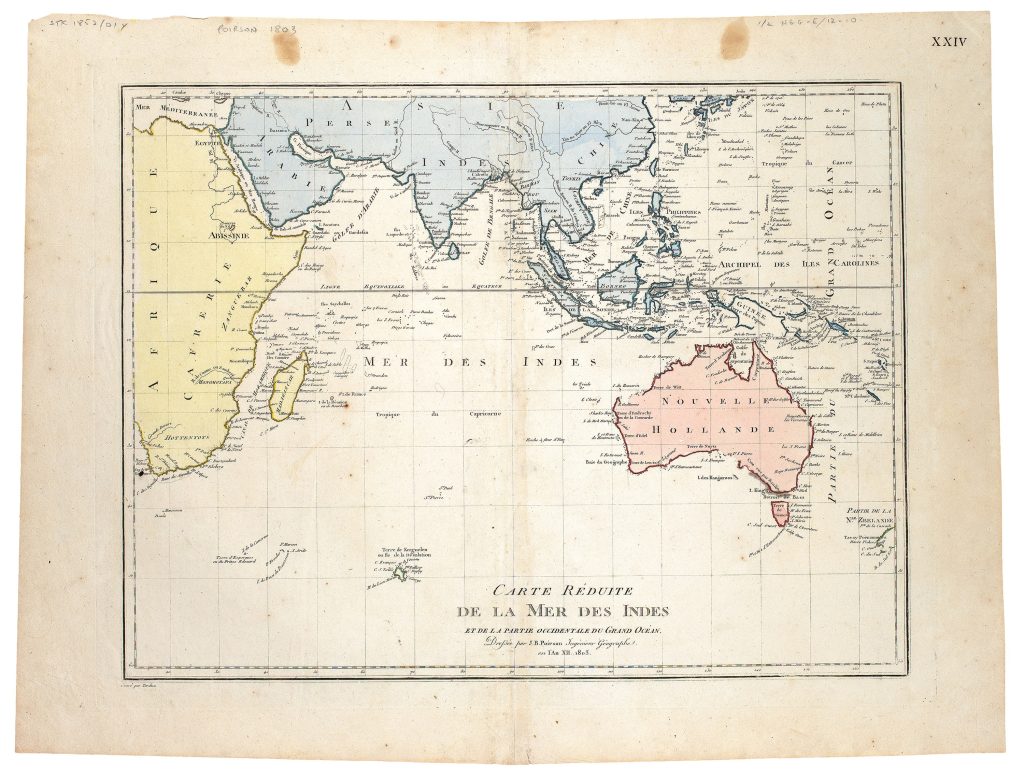
Jean Baptiste Poirson was a French geographer, globemaker, and mapmaker active in the late eighteenth and early nineteenth centuries. After studying mathematics, he worked with the geographer Edme Mentelle, and from about 1790 maps began appearing under his own name. This chart was drawn by Poirson, engraved by Jean Baptiste Pierre Tardieu, and issued as plate XXIV in the atlas accompanying Edme Mentelle and Conrad Malte-Brun’s Géographie mathématique, physique et politique de toutes les parties du monde, published in Paris in 1804. The chart itself is dated 1803.
As part of Mentelle and Malte-Brun’s broad geographical compendium, Poirson’s chart brought together nautical routes, recent voyages, and new information about New Holland, the Indian Ocean, and the western Pacific. Its scope places Australia within the maritime geography of the Indian Ocean and the western Grand Océan, linking the continent to French, British, Dutch, and earlier European navigation across the Indo-Pacific. The Australian coastline is especially significant. The chart records Nicolas Baudin’s voyage to Australian waters, authorised by Napoleon Bonaparte in 1800. In 1802, Baudin sailed west along the southern coast of Australia, marked here as Côte vue par Baudin, and encountered Matthew Flinders at what is now Encounter Bay. Kangaroo Island is labelled Île des Kanguroos, reflecting Baudin’s work in the region.
The map also incorporates earlier British and French exploration. The east coast of Australia reflects the discoveries of James Cook, while the tracks of L’Espérance and La Recherche record the expedition commanded by Antoine Bruni d’Entrecasteaux in search of the lost vessels of Jean-François de Galaup, Comte de Lapérouse. The plate number “XXIV” appears at upper right.
Within the collection, this chart is closely connected with earlier maps that placed New Holland and New Guinea within Asian and Pacific geography, including Abraham Ortelius’s Indiae Orientalis, Insularumque Adiacientium Typus (106), Ortelius’s Maris Pacifici (221and 118), and Thomas Pennant’s Map for Mr Pennants Outline of the Globe (178), which captures the moment when Bass Strait was only beginning to be recognised in print.
Poirson, Jean Baptiste (1761–1831)
Mentelle, Edme and Conrad Malte-Brun, Géographie mathématique, physique et politique de toutes les parties du monde, Paris: Henry Tardieu and Laporte, An XIII [1804].
1803, first
Copperplate engraving
31
R3 Uncommon - dealers can usually obtain a copy