
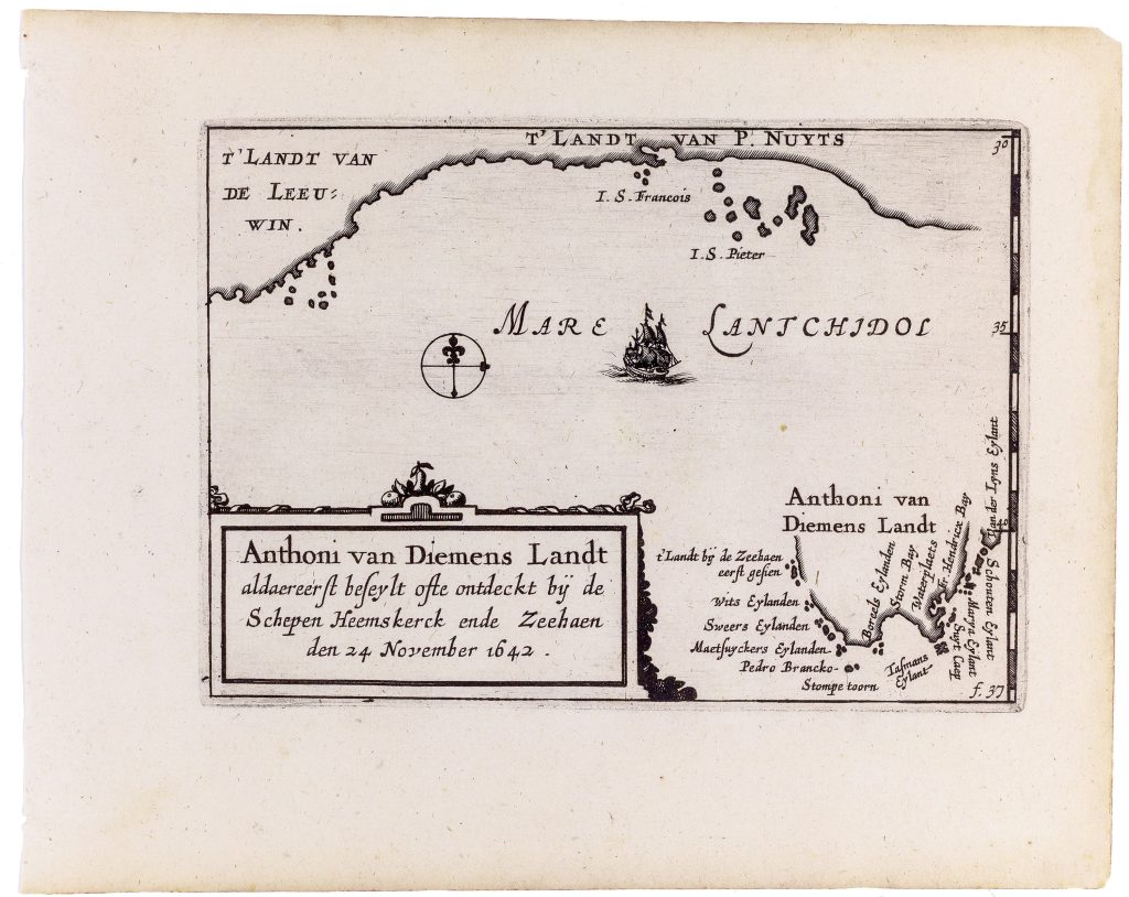
Anthoni van Diemens Landt aldaereerst beseylt ofte ontdeckt by de Schepen Heemskerck ende Zeehaen den 24 November 1642
Claes Jansz. Visscher was an Amsterdam engraver, publisher, and map seller whose firm became one of the important Dutch map publishing houses of the first half of the seventeenth century. In 1611 he established his publishing house on the Kalverstraat, close to leading contemporaries such as Pieter van den Keere and Jodocus Hondius I. The firm was continued by his son Nicolaes Visscher I and later by his grandson Nicolaes Visscher II.
In 1649 Claes Jansz. reworked and expanded Barent Langenes’s Caert-thresoor, an older small-format atlas first published in Amsterdam in 1598 by Cornelis Claesz. After Claesz.’s death in 1609, the atlas plates passed through several owners before being acquired by Visscher who reissued the material as Tabularum geographicarum contractarum libri quatuor denuo recogniti. The compact atlas was divided into four parts: Europae, Asiae, Africae, and Americae. Alongside the inherited plates, Visscher added twenty-three newly engraved maps, among them this map of Anthoni van Diemens Landt, ’t Landt van de Eendracht (12), Iava Maior (371), and several plates engraved by Benjamin Wright (369, 370). The atlas also included two revised world maps: Typus Orbis Terrarum (292) and Iehova (293), both originally engraved by Jodocius Hondius I for the 1598 Caert-thresoor (294and 296).
This map records the discovery of Van Diemen’s Land, now Tasmania, by Abel Tasman’s ships Heemskerck and Zeehaen on 24 November 1642. Unlike earlier speculative representations of the southern oceans, the plate presents a defined coastal outline with fourteen place names along the south-western, southern, and south-eastern coasts. It also includes part of the southern coast of New Holland, including ’t Landt van de Leeuwin and ’t Landt van P. Nuyts, linking Tasmania to earlier Dutch discoveries along the south and south-western coasts of the continent. The surrounding sea is labelled Mare Lantchidol, a name used in Dutch mapping of the East Indies and the Southland. As a compact atlas map, the plate is an early printed representation of Tasman’s discoveries. It translated VOC voyage information into a form suitable for wider European readers and placed Van Diemen’s Land within the expanding Dutch image of the southern world.
Within the collection, this map is closely connected with Visscher’s related ’t Landt van de Eendracht (12), which shows the western Australian coast and the sea route north toward Java. It also relates to Valentijn’s later Tasman map (177), John Thornton’s chart of New Holland (102), and Vaugondy’s Carte réduite de l’Australasie (17), all of which show later stages in the printed mapping of Tasman’s discoveries and Australia’s incomplete outline.
Visscher, Claes Jansz. (1587–1652)
Tabularum geographicarum contractarum libri quatuor denuo recogniti, Amsterdam: Claes Jansz. Visscher, 1649
1649, first
Copperplate engraving
11
R1 Extremely rare - occasionally seen on the market