
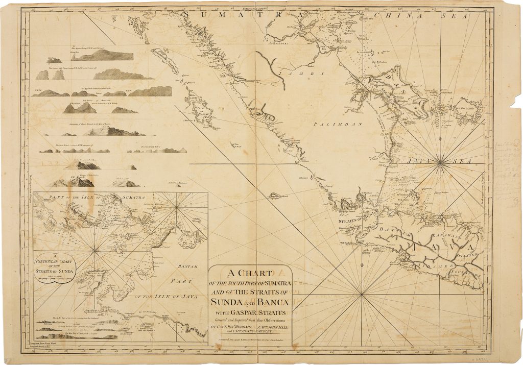
Chart of the South Part of Sumatra and of the Straits of Sunda and Banca
Robert Laurie and James Whittle were London map and chart publishers who took over Robert Sayer’s stock in the 1790s and continued issuing separately published nautical charts for British maritime use.
This first Laurie and Whittle issue, published in London in 1794, charts the southern part of Sumatra, the Sunda and Bangka Straits, Gaspar Strait, and the approaches to western Java.
It incorporates corrections and improvements from the observations of Captain Joseph Huddart, Captain John Hall, and Captain Henry Smedley.
The chart gives detailed hydrographic treatment to one of the principal maritime corridors between the Indian Ocean, the Java Sea, and the South China Sea.
It includes dense soundings, sailing channels, shoals, reefs, coastal hazards, islands, and anchorages.
A large inset of the Sunda Strait increases its practical value for ships approaching or leaving Batavia through the passage between Sumatra and Java.
Eight coastal profile views support visual recognition from the sea, including Padang, Pulo Pesang, Broken Point, Pulo Tellores, Mount Monopin, the Seven Islands, Pulo Taya, and Pulo Linging.
These profiles show the chart’s working purpose: it was intended not only to describe coastlines, but to help mariners identify landfalls, avoid hazards, and choose safe passages through difficult waters.
The present example is further distinguished by contemporary pencil annotations, including sailing directions and a reference to Hendrick Rock.
These additions provide evidence of practical shipboard use and show how printed charts could be supplemented by mariners’ own observations.
This chart is closely connected with Laurie and Whittle’s wider chart of the Indian and Pacific Oceans (35), which places the Sunda and Bangka Straits within the broader route system from the Cape of Good Hope to New Holland, the China Sea, and Japan.
It also relates closely to Johannes van Keulen II’s charts of the Sunda Strait (44), the Sunda and Bangka Straits (45), the coasts and straits around Sumatra (225), and the wider Southeast Asian route chart (220).
Together, these works show how the approaches to Batavia and the western Java Sea were charted across Dutch and British maritime publishing traditions.
Laurie, Robert (1755–1836); Whittle, James (1757–1818)
London: Laurie & Whittle, 1794
1794, first
Copperplate engraving
469
R3 Uncommon - dealers can usually obtain a copy