
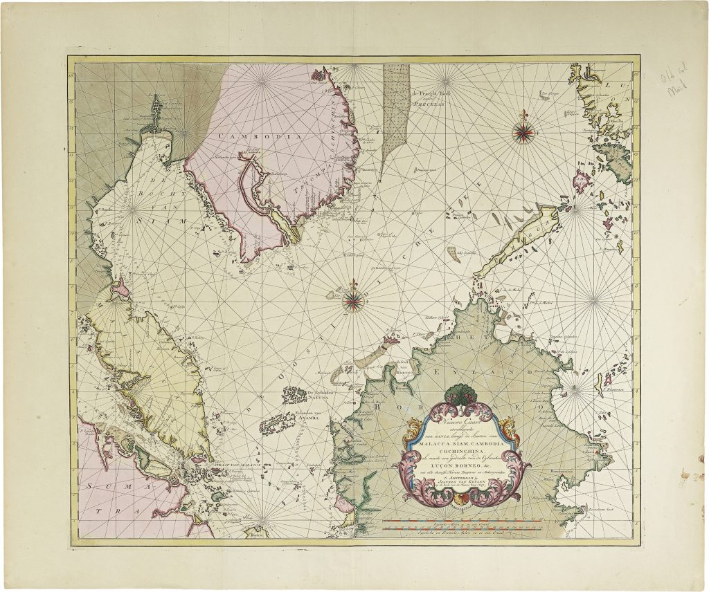
Nieuwe caart strekkende van Banca langs de kusten van Malacca, Siam, Cambodia, Cochinchina
The Van Keulen publishing house, In de Gekroonde Lootsman (“In the Crowned Pilot”), was founded in Amsterdam by Johannes van Keulen I in 1678 and became one of the leading Dutch firms producing maps, sea charts, atlases, and pilot books.
After Johannes I and his son Gerard developed the business, it passed to Gerard’s son, Johannes van Keulen II.
Johannes II is especially known for issuing the sixth and final volume of De nieuwe groote lichtende Zee-fakkel in 1753, devoted to Asian and Indian Ocean navigation.
The volume brought into print closely guarded VOC hydrographic knowledge, including information derived from manuscript charts and sailing directions that had previously been restricted because of their commercial and strategic value.
The fuller title wording records: Nieuwe caart strekkende van Banca langs de kusten van Malacca, Siam, Cambodia, Cochinchina: als meede een gedeelte van de eylanden Luçon, Borneo.
The Zee-fakkel included this sea chart which shows a wide arc of Southeast Asian waters, from Bangka and the Straits of Malacca through Siam, Cambodia, Cochinchina, Borneo, Luzon, and the approaches to the Philippines and South China Sea.
It was designed for ships moving from Batavia through the Straits of Singapore and Malacca, or northward toward Siam, Cambodia, Manila, Macao, Canton, and Nagasaki.
The chart gives particular attention to coast-hugging routes into the Gulf of Thailand and toward the Chao Phraya River.
It also traces river systems leading inland toward important trading centres, including Lopburi in Siam and De Stad Cambodia, probably Lawec, a Cambodian capital and VOC trading site.
These details show how coastal hydrography, river access, and supply networks were connected in Dutch navigation and trade.
This chart is closely connected with Van Keulen’s related charts of the Sunda and Bangka Straits (44and 45), the coasts around Sumatra (225), and the China-coast charts in the same volume (316and 317).
Together, they show the navigational chain linking Batavia, western Indonesia, mainland Southeast Asia, the Philippines, and the China trade.
Keulen II, Johannes van (1704–1755)
De nieuwe groote lichtende Zee-fakkel, vol. 6, Amsterdam: Johannes van Keulen II, 1753
1753, first
Copperplate engraving
220
Only copy