
Laurie and Whittle’s chart of the Indian and Pacific Oceans
Robert Laurie and James Whittle were London map and chart publishers who took over Robert Sayer’s stock in the 1790s and continued issuing separately published nautical charts for British maritime use.
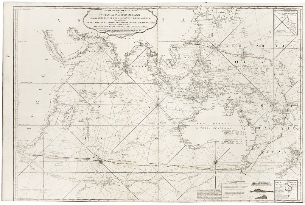
This chart was first issued by Laurie and Whittle in 1794, reworked from an earlier Robert Sayer chart of the Indian and Pacific Oceans.
The present example is the 1800 third Laurie and Whittle state.
The chart extends from the Cape of Good Hope across the Indian Ocean to New Holland, New Zealand, New Caledonia, New Britain, New Ireland, New Guinea, Japan, and the China Sea.
Australia is labelled New Holland, with the eastern coast identified as the Eastern Coast of New South Wales.
The chart retains unresolved late eighteenth-century geography, including the speculative connection between Van Diemen’s Land and the Australian mainland before the publication of Bass Strait in British charts.
The title emphasises that the chart includes the tracks of English, Spanish, French, and Dutch navigators, with particular attention to the voyages of the Walpole and the Royal Admiral.
Captain Thomas Butler, commanding the Walpole, sailed from the Cape of Good Hope to China by a route south and east of Australia.
Captain Essex Henry Bond’s voyages in the Royal Admiral also linked the chart to British navigation between England, Australia, the East Indies, and China; two of his voyages were associated with convict transportation to Australia.
Other plotted routes include those of Luis Váez de Torres, William Dampier, Philip Carteret, Louis Antoine de Bougainville, Jean-François-Marie de Surville, Marc-Joseph Marion du Fresne, Julien Crozet, Yves-Joseph de Kerguelen-Trémarec, James Cook, Tobias Furneaux, John Marshall, Thomas Gilbert, James Larkins, and other late eighteenth-century navigators.
The accumulation of these tracks turns the chart into a historical record of European movement across the Indian and Pacific Oceans.
This chart is closely connected with Robert Laurie and James Whittle’s chart of southern Sumatra and the Sunda and Bangka Straits (469), which treats one of the key passages into the same Indian Ocean and East Indies route system in greater detail.
It also connects with earlier Dutch charts of the East Indies, Southeast Asia, and the western approaches to the Pacific, including Johannes van Keulen I’s charts (83and 95), the Pieter Goos/Van Keulen chart fragment (266), Hendrik Doncker’s East Indies charts (33, 234, and 347), and Robert Dudley’s chart of the western and northern coasts of Australia (172).
Together, these works trace the movement from Dutch VOC hydrography to later British commercial charting of the Indian and Pacific Oceans.
Laurie, Robert (1755–1836); Whittle, James (1757–1818)
Separate publication.
London: R.
Laurie & J.
Whittle, 1794
1800, third
Robert Sayer antecedent chart, 1787; reissued 1790
Copperplate engraving
35
R2 Very rare - one or two copies appear on the market