
Typus orbis universalis
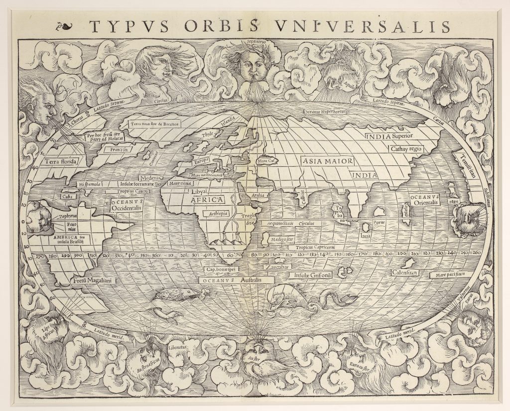
Sebastian Münster was a German humanist, Hebraist, cosmographer, and mapmaker whose 1540 edition of Claudius Ptolemy’s Geographia, combined the inherited geography of antiquity with new maps of the modern world. Published at Basel by Heinrich Petri, the volume included twenty-seven Ptolemaic maps and twenty-one modern maps, among them this world map. Münster’s Geographia was subsequently reprinted in Latin in 1542, 1545, and 1552.
The map presents the world in an oval projection derived from Benedetto Bordone’s earlier world map (7). It shows a fully navigable world, with the Indian Ocean open, the Strait of Magellan marked at the southern tip of South America, and a wide Pacific separating Asia from the Americas. The label Mare pacificum appears at lower right, an important early printed use of the name Pacific Ocean. Münster’s depiction of the Americas combines new reports with continuing uncertainty. North America appears as Terra Florida, while Europe extends westward to Terra nova sive de Bacalhos, or “New Land of the Codfish.” Between this land and Francisca, Münster marks a passage with the inscription “The route to the Moluccas passes through this strait, ” reflecting continuing hopes for a northern or western route to Asia. Farther south, a V-shaped body of water separates Terra Florida and Francisca, echoing Giovanni da Verrazzano’s mistaken interpretation of the waters behind the North American coast as part of the Pacific.
South America appears as America seu insula Brasilii, or “America, or the Island of Brazil, ” with the Río de la Plata marked. Beyond the Strait of Magellan is a small unnamed landmass, showing Münster’s awareness of Ferdinand Magellan’s circumnavigation without yet developing the large southern continent found on some later world maps. Africa is drawn with a more recognisable outline than much of the newly mapped world, while the Nile rises from two lakes fed by streams from an unidentified mountain range, recalling the classical tradition of the Mountains of the Moon. The map is framed by clouds and wind heads, with the east and west winds placed within the oval itself. Two sea monsters appear in the Oceanus Australis, and a sailing ship fires its cannons in the Pacific. The 1540 issue can be distinguished by the single decorative printer’s device to the left of the title. The map also appeared in the first four editions of Münster’s Cosmographia in 1544, 1545, 1546, and 1548.
Within the collection, this map is closely connected with Münster’s earlier Typus cosmographicus universalis (119), the later 1550 version of Typus orbis universalis (90), and the Ptolemaic world map La Seconde Table Generale Selon Ptol (325).
Münster, Sebastian (1488–1552)
Geographia universalis, vetus et nova complectens Claudii Ptolemaei Alexandrini enarrationis libros VIII, Basel: Heinrich Petri, 1540
1540, first
Woodcut
91
R1 Extremely rare - occasionally seen on the market