
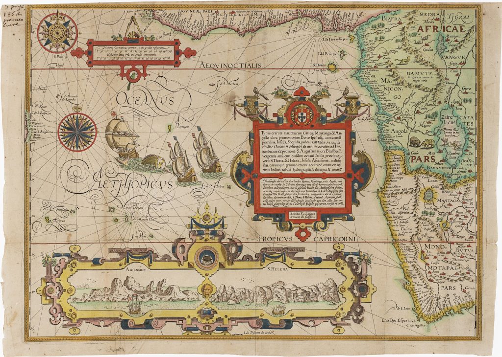
Typus orarum maritimarum Guineae, Manicongo & Angolae ultra Promentorium Bonae spei
Jan Huygen van Linschoten was a Dutch traveller, merchant, and writer whose years in Portuguese Goa gave him access to closely held information about Iberian navigation and overseas trade. In 1583 he travelled to Goa, where he served as secretary to João Vicente da Fonseca, the Portuguese Archbishop of Goa. This position placed him near the centre of Portuguese administration and commerce in the Indian Ocean.
After returning to the Dutch Republic in 1592, Linschoten prepared his observations for publication with the Amsterdam publisher Cornelis Claesz. His Itinerario, Voyage ofte Schipvaert naer Oost ofte Portugaels Indien was published in Amsterdam in 1596. Although best known for opening up Portuguese knowledge of the East Indies, the work also covered the wider Iberian maritime world, including Africa, Brazil, Spanish America, and the sea routes linking Europe, the Atlantic, and Asia. An English translation, Discours of Voyages into ye Easte & West Indies, followed in London in 1598 (356). This map follows the western coast of Africa from Guinea through the Kingdom of Kongo and Angola and around the Cape of Good Hope. For ships sailing between Europe and Asia, this coastline was not a distant edge of the world but part of the main sea road to the Indian Ocean. The map therefore belongs directly to the navigational geography of the East Indies trade, even though its subject is western and southern Africa.
At the bottom are two inset coastal views. Ascension Island appears on the left, with jagged peaks and ships offshore. Saint Helena appears on the right, with a small boat approaching a wooded landing place. Both islands were important stopping and resupply points for ships making the long voyage between Europe, Africa, and the East Indies. This map belongs to the wider cartographic and illustrative programme of Linschoten’s Itinerario, which included a world map by Petrus Plancius (71), first published in 1594, and five regional maps associated with Arnold Florent van Langren and Henricus Florent van Langren: Asia and the Indian Ocean (254), East and Southeast Asia (74), East Africa and the western Indian Ocean (278), South and Central America (279) and this present map of South and West Africa.
Linschoten, Jan Huygen van (1563–1611)
Itinerario, Voyage ofte Schipvaert naer Oost ofte Portugaels Indien, Amsterdam: Cornelis Claesz., 1596
1596, first
Copperplate engraving
277
R2 Very rare - one or two copies appear on the market