
Delineatio omnium orarum totius Australis partis Americae, dictae Peruvianae, a R. de la Plata, Brasiliam, Pariam, & Castellam
Jan Huygen van Linschoten was a Dutch traveller, merchant, and writer whose years in Portuguese Goa gave him access to closely held information about Iberian navigation and overseas trade. In 1583 he travelled to Goa, where he served as secretary to João Vicente da Fonseca, the Portuguese Archbishop of Goa. This position placed him near the centre of Portuguese administration and commerce in the Indian Ocean.
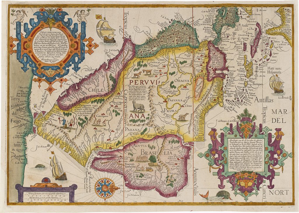
After returning to the Dutch Republic in 1592, Linschoten prepared his observations for publication with the Amsterdam publisher Cornelis Claesz. His Itinerario, Voyage ofte Schipvaert naer Oost ofte Portugaels Indien was published in Amsterdam in 1596. Although best known for opening up Portuguese knowledge of the East Indies, the work also covered the wider Iberian maritime world, including Africa, Brazil, Spanish America, and the sea routes linking Europe, the Atlantic, and Asia. An English translation, Discours of Voyages into ye Easte & West Indies, followed in London in 1598 (356). This map shows South and Central America from the Río de la Plata through Brazil, Paria, Castella, the Antilles, Hispaniola, Cuba, and Cape Florida. It also follows the Pacific coast from Panama and Nombre de Dios southward through Peru and Chile. Rather than describing the interior in detail, the map concentrates on the coasts, ports, and passages that mattered to European navigation and trade.
At the southern tip of South America, the Strait of Magellan marks the entrance to the imagined far south. Tierra del Fuego is shown not as an island group, but as part of a larger southern landmass. This links the map to late sixteenth-century ideas of Terra Australis, when the lands beyond the strait were still often understood as the northern edge of a vast southern continent. This map belongs to the wider cartographic and illustrative programme of Linschoten’s Itinerario, which included a world map by Petrus Plancius (71), first published in 1594, and five regional maps associated with Arnold Florent van Langren and Henricus Florent van Langren: East and Southeast Asia (74), Asia and the Indian Ocean (254), South and West Africa (277), East Africa and the western Indian Ocean (278), and the present map of South and Central America.
Linschoten, Jan Huygen van (1563–1611)
Itinerario, Voyage ofte Schipvaert naer Oost ofte Portugaels Indien, Amsterdam: Cornelis Claesz., 1596
1596, first
Copperplate engraving
279
R2 Very rare - one or two copies appear on the market