
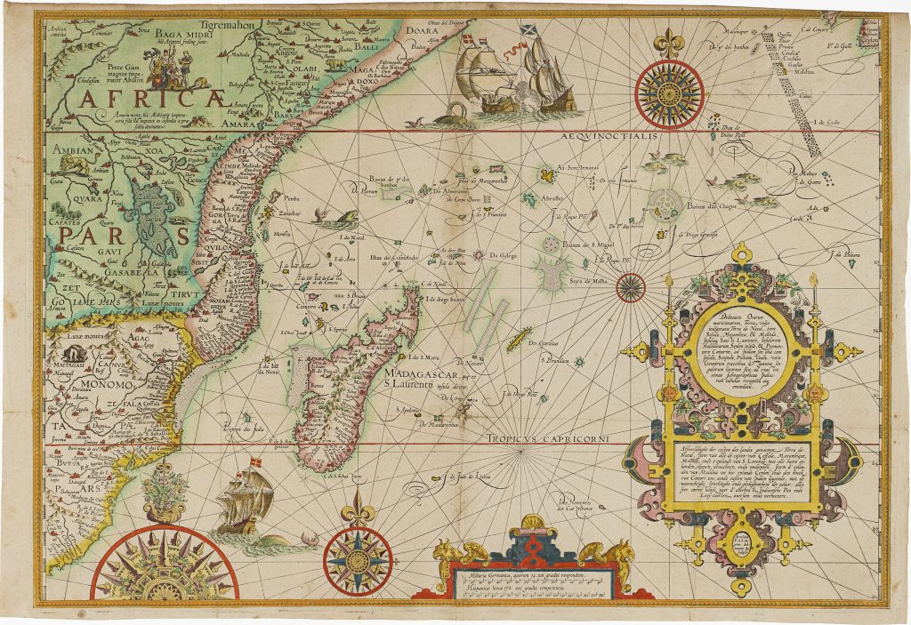
Delineatio orarum maritimarum, terrae vulgo indigetatae terra do Natal item Sofalae, Mozambicae & Melindae, insulæque
Jan Huygen van Linschoten was a Dutch traveller, merchant, and writer whose years in Portuguese Goa gave him access to closely held information about Iberian navigation and overseas trade. In 1583 he travelled to Goa, where he served as secretary to João Vicente da Fonseca, the Portuguese Archbishop of Goa. This position placed him near the centre of Portuguese administration and commerce in the Indian Ocean.
After returning to the Dutch Republic in 1592, Linschoten prepared his observations for publication with the Amsterdam publisher Cornelis Claesz. His Itinerario, Voyage ofte Schipvaert naer Oost ofte Portugaels Indien was published in Amsterdam in 1596. Although best known for opening up Portuguese knowledge of the East Indies, the work also covered the wider Iberian maritime world, including Africa, Brazil, Spanish America, and the sea routes linking Europe, the Atlantic, and Asia. An English translation, Discours of Voyages into ye Easte & West Indies, followed in London in 1598 (356). This map follows the western Indian Ocean route from the East African coast toward India and the East Indies. It extends from Terra do Natal, Sofala, Mozambique, and Melinde to Madagascar, the Maldives, Ceylon, and the coast of India near Cape Comorin. Drawing on Portuguese maritime information available to Linschoten in Goa, it presents the ports, islands, reefs, and sea lanes that shaped navigation between East Africa, Madagascar, India, and the wider Asian trade.
The map combines practical coastal geography with decorative and symbolic elements. Compass roses, ships, sea monsters, and scenes of maritime activity animate the ocean, while the interior of Africa carries older geographical and legendary material. The Nile rises from the Lake of Zaflan, reflecting contemporary theories about the river’s source. Nearby appears Prester John, the legendary Christian ruler long believed by Europeans to govern a powerful kingdom somewhere in Africa or Asia. A cartouche on the right gives the title in Latin and Dutch and states that the map was accurately revised and improved from the finest Indian maps. This claim is important: it presents the map not as speculation, but as knowledge drawn from Portuguese and Indo-Portuguese maritime sources. For Dutch readers in 1596, such information helped explain the sea route around Africa and across the Indian Ocean at a time when the Dutch were seeking access to Asian trade.
This map belongs to the wider cartographic and illustrative programme of Linschoten’s Itinerario, which included a world map by Petrus Plancius (71), first published in 1594, and five regional maps associated with Arnold Florent van Langren and Henricus Florent van Langren: Asia and the Indian Ocean (254), South and West Africa (277), East and Southeast Asia (74), South and Central America (279) and this present map of East Africa and the western Indian Ocean.
Linschoten, Jan Huygen van (1563–1611)
Itinerario, Voyage ofte Schipvaert naer Oost ofte Portugaels Indien, Amsterdam: Cornelis Claesz., 1596
1596, first
Copperplate engraving
278
R2 Very rare - one or two copies appear on the market