
Great Britain’s Coasting Pylot
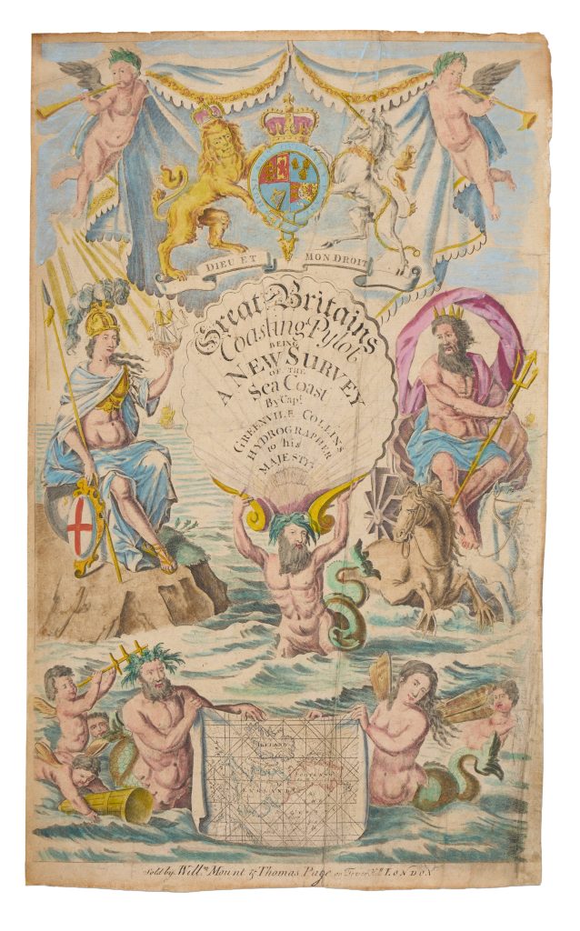
Greenvile Collins was an English naval officer, hydrographer, and surveyor whose Great Britain’s Coasting Pilot was the first systematic printed sea atlas devoted to the coasts of Britain. The work was first published in London in 1693, following Collins’s royal commission to survey the coastline. This title page belongs to a later issue, as shown by the imprint at the foot: “Sold by Will. Mount & Thomas Page on Tower Hill, London.”
The title page presents Collins’s coasting pilot as both a practical work of hydrography and a statement of British maritime authority. At the top, trumpet-blowing putti hold a mantle displaying the royal arms of William and Mary, with the Dutch Lion and the Orange-Nassau motto Je maintiendrai. This heraldic display places the atlas firmly within the post-1688 Williamite monarchy. Wells describes the title page as a tripartite composition that brings together royalty, nationhood, mythology, and maritime supremacy.
At the centre, the title appears on a large scallop shell held above the sea by a bearded merman. The shell cartouche identifies the work as Great Britains Coasting Pylot, “a new survey of the sea coast,” by Captain Greenvile Collins, hydrographer to Their Majesties. The merman’s body gives physical force to the image, turning the title itself into an emblem of maritime strength.
Britannia sits at left on a sea-girt rock, wearing classical armour and holding a spear, the shield of St George, and a three-masted ship. She represents Britain not only as a land or nation, but as a maritime power. Opposite her, Neptune sits in a shell-chariot drawn by sea-horses, holding his trident beneath a billowing mantle. Together, Britannia and Neptune frame the atlas as an assertion of command over the surrounding seas. Their pairing gives classical and national authority to Collins’s hydrographic survey.
The lower part of the title page brings the allegory back to the practical function of the atlas. A merman and winged mermaid hold an unrolled chart of Britain and Ireland, crossed by rhumb lines and oriented with north to the right. Putti around the chart hold instruments of navigation and survey, including a cross-staff, a lead-line, and a buoy. These objects identify the atlas as a working navigational tool as well as a symbolic image of the nation. Wells emphasises that these instruments represented the modern state of navigational and survey science before the regular use of the sextant.
The title page therefore introduces the Coasting Pilot on several levels at once. It celebrates the authority of the Crown, the maritime identity of Britain, the classical rule of the seas, and the practical work of coastal survey. Its imagery presents the British coastline as something that could be measured, charted, ordered, and defended through royal authority and hydrographic expertise.
Great Britain’s Coasting Pilot: Being a New and Exact Survey of the Sea Coast, London: Richard Mount, 1693
1698
Copperplate engraving
482
R3 Uncommon - dealers can usually obtain a copy