
Asia ex magna orbis terre descriptione
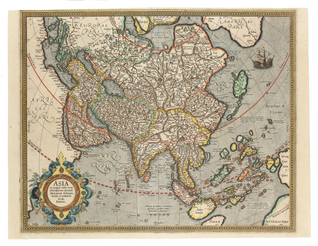
Gerard Mercator was a Flemish cartographer, cosmographer, and instrument maker whose work shaped European mapping in the second half of the sixteenth century. This map of Asia was first published posthumously in the 1595 Atlas sive Cosmographicae meditationes de fabrica mundi et fabricati figura, issued by his son Rumold Mercator. The map distils the Asian geography of Mercator’s great 1569 world map into atlas form.
The map presents Asia as a continent of enormous scale and commercial importance, extending from the eastern Mediterranean and Arabia across Persia, India, Central Asia, China, Japan, Southeast Asia, the Philippines, the Moluccas, New Guinea, and the northern edge of the southern continent. Its dense network of names reflects Mercator’s attempt to reconcile classical geography, travel literature, and more recent European maritime knowledge.
Southeast Asia is especially significant. Sumatra, Java, Borneo, the Philippines, and the Moluccas are shown within the wider maritime geography of Asian trade, while New Guinea appears at the far right and Australis Pars enters at the lower-right edge. These details place Asia within a broader world of uncertain seas, island routes, spice commerce, and speculation about the far south.At the upper right, part of North America appears as Americae Pars, separated from Asia by the Strait of Anian. The names Anian and Quivira connect the map to Spanish reports and legends about the northwest of America, including hopes for a northern passage between the Atlantic and Pacific. Mercator’s Asia therefore reaches beyond the continent itself, linking Asian geography to Pacific navigation, American discovery, and the imagined southern land.
Within the collection, this map is closely connected with Michael Mercator’s map of the Americas (464), also from the Mercator atlas tradition; together they show how Asia and America were mapped in relation to northern passageways, Pacific geography, and the uncertain southern continent. It also relates to Sebastian Münster’s Asia maps (394, 5, and 96), which provide earlier and later printed comparisons for Asia and Southeast Asia. Johannes Metellus’s Pacific map (132), his Chica sive Patagonica et Australis Terra (226), and Pierre Mariette’s later East Indies map (354) are useful comparisons because they also show New Guinea, the Pacific, and Terra Australis as unresolved parts of European geography.
Mercator, Gerard (1512–1594)
Atlas sive Cosmographicae meditationes de fabrica mundi et fabricati figura, Amsterdam: Rumold Mercator, 1595
1595, first
Copperplate engraving
14
R3 Uncommon - dealers can usually obtain a copy