
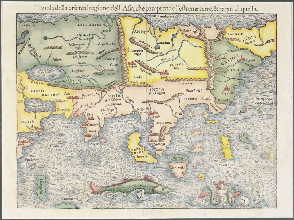
Tavola della oriental regione dell'Asia, che comprende l'estreme terre, & regni di quella
Sebastian Münster was a German humanist, Hebraist, cosmographer, and mapmaker based in Basel. His 1540 edition of Claudius Ptolemy’s Geographia placed twenty-seven ancient Ptolemaic maps alongside twenty-one new “modern” maps, including India Extrema, XIX, nova tabula (5). That map presented eastern Asia and Southeast Asia with less dependence on Ptolemy’s ancient geography and greater use of travel literature and Portuguese maritime information.
Münster later reused and adapted many of his maps in the Cosmographia, his broader description of the world first published in German in 1544. After Münster’s death in 1552, the Petri publishing house continued to issue the work in several languages. This Italian version appeared in the 1558 Italian edition of Münster’s Cosmographia and corresponds to his earlier India Extrema (5). The map extends across the Indian Ocean and eastern Asia, from Arabia, Persia, India, and the Caspian Sea to Cathay, Mangi, China, Japan, the Malay Peninsula, Sumatra, Java, the Moluccas, and the islands of the eastern seas. It marks important centres of trade and navigation, including Aden, Ormus, Goa, Calicut, Malacca, and the Moluccas, reflecting European awareness of the commercial routes that connected the Indian Ocean with Southeast Asia.
One of the map’s most distinctive features is the cluster of islands off the coast of China labelled Archipelagus 7448 insularum. This detail comes from Marco Polo’s account of the islands near Zipangri, or Japan, and shows how medieval travel writing continued to shape Renaissance cartography. The map also preserves older geographical uncertainties, including Taprobana Sumatra, the separation of Iaua minor and Iaua maior, and the placement of islands and kingdoms across the eastern ocean. The lower ocean is animated by a large sea monster and a mermaid-like figure. These details give the map a visual character shared with Münster’s earlier woodcut and present the eastern seas as places of trade, danger, and marvel.
Within the collection, this map is directly connected with Münster’s 1540 India Extrema (5), from which it derives, and with his earlier Asia Maior (232). It also relates to Münster’s Ptolemaic Tabula Asiae XI (363), which presents Southeast Asia through a much older geographical framework.
Münster, Sebastian (1488–1552)
Geographia universalis, vetus et nova complectens Claudii Ptolemaei Alexandrini enarrationis libros VIII, Basel: Heinrich Petri, 1540
1558, Italian Cosmographia edition
Woodcut
96
R2 Very rare - one or two copies appear on the market