
Americae sive novi orbis, nova descriptio / Die newen inseln so hinder Hispaniam gegen Orient, bey dem landt Indie gelegen
Sebastian Münster was a German humanist, Hebraist, cosmographer, and mapmaker based in Basel. His Cosmographia, first published in German in 1544, was a large illustrated description of the known world, combining geography, history, peoples, cities, natural wonders, and maps. Münster died in 1552, but the work continued to be revised and reissued by the Petri publishing family in Basel.
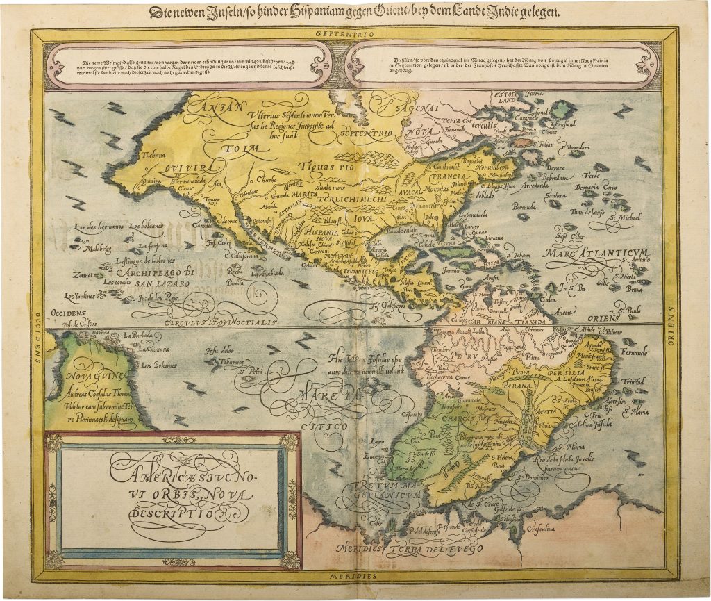
In 1588, Sebastian Petri issued a substantially revised version of the Cosmographia with a new set of woodcut maps, many of them updated in response to later sixteenth-century atlas geography. This map of the Americas, from the 1592 German edition, belongs to that later Petri revision. It reflects the influence of Abraham Ortelius’s map of America (221). The map presents North, Central, and South America together with parts of the Pacific, New Guinea, and the southern continent. North America is still marked by uncertainty: an inscription in the far north states that the regions further towards the north are still unknown. South America is more fully formed, with Persilia or Brazil identified as discovered by the Portuguese in 1504, and Patagonia described as a region where the inhabitants are giants.
The southern and Pacific regions preserve older and speculative geography. New Guinea appears with an inscription referring to Andrea Corsali and suggesting an association with the “land of the dwarfs.” Below the equator, another inscription notes reports of islands rich in gold. At the lower edge, Merides terra del Fuego appears near the imagined southern land, linking the map to late sixteenth-century ideas about Terra Australis and the still uncertain geography beyond the Strait of Magellan. These details show how the map combines a more current outline of the Americas with reports, marvels, classical echoes, and speculative geography around the edges of the known world.
Within the collection, this map is closely connected with Münster’s later Petri world map from the same 1592 edition (#393), where Terra Australis non dum cognita, Beach, Lucach, and Maletur appear across the southern hemisphere. It also relates to Münster’s earlier modern world maps, Typus orbis universalis (91and 90). Ortelius’s Americae sive novi orbis nova descriptio (221) provides an important comparison for the later sixteenth-century mapping of the Americas.
Münster, Sebastian (1488–1552)
Cosmographei oder beschreibung aller länder, Basel: Sebastian Petri, 1588
1592, second
Woodcut
392
R1 Extremely rare - occasionally seen on the market