
Carte générale de la Nouvelle Hollande No. 1
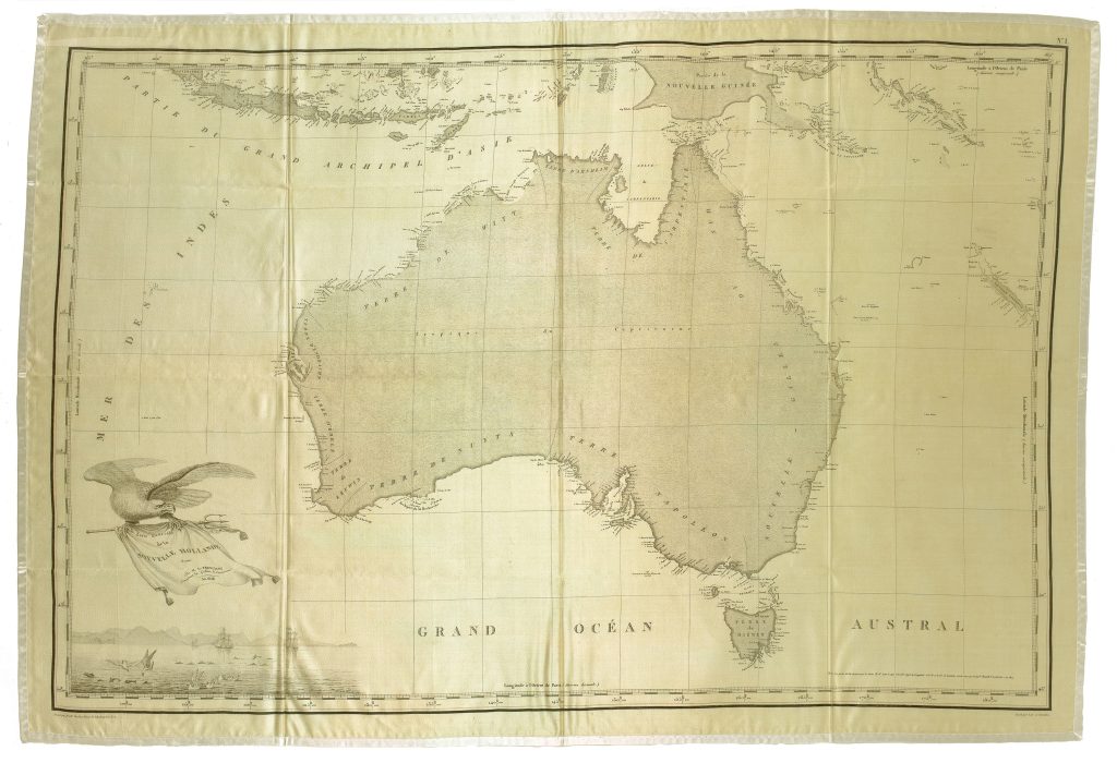
Louis Claude de Freycinet was one of the principal hydrographers of Nicolas Baudin’s expedition to the southern lands. This proof map of Australia, titled Carte de la Nouvelle Hollande, represents an early state of the general map later published in the atlas to the official Baudin voyage account. The title records Freycinet as commander of the schooner Casuarina and gives the date 1808.
The map reflects the extensive surveys conducted during Nicolas Baudin’s expedition to the southern lands between 1800 and 1803. The voyage left France in October 1800 with Baudin commanding Le Géographe, accompanied by Le Naturaliste under Jacques Félix Emmanuel Hamelin. After reaching the western coast of Australia at Geographe Bay in May 1801, the expedition surveyed parts of the west coast before sailing north to Timor. From Timor the ships returned south, reaching Van Diemen’s Land in early 1802 before continuing toward the southern coast of Australia. In April 1802, Baudin encountered Matthew Flinders at Encounter Bay, where both French and British expeditions were charting the same coastline. After calling at Sydney, Le Naturaliste returned to France with the expedition’s natural history collections, while Baudin acquired the smaller vessel Casuarina from Governor Philip Gidley King. Under Freycinet’s command, Casuarina continued survey work around King Island, Kangaroo Island, King George Sound, and Shark Bay before the expedition returned north via Timor. Baudin died in 1803 during the return voyage, and the official account was first taken up by the naturalist François Péron. After Péron’s death in 1810, Freycinet assumed responsibility for the remaining publication, including the cartographic material. The 1811 atlas included the published version of this general map of Australia, together with Freycinet’s detailed chart of the southern coast, Terre Napoléon (169).
In the lower left corner, the French Imperial Eagle holds the title banner, with a coastal scene below showing ships and Australian fauna, designed by Charles-Alexandre Lesueur. This imagery gives the map an explicitly imperial and scientific character, presenting Nouvelle Hollande as both a field of hydrographic survey and a region framed through French exploration, naming, and publication.
Within the collection, this proof can be compared with the 1811 published atlas examples (64and 168) and the reduced 1824 version (39). Together, these maps show the transformation of Freycinet’s Australian cartography from early proof to published imperial atlas plate and later historical reduction. Freycinet’s detailed chart of Terre Napoléon (169) provides the southern-coast counterpart to this general map, while the Partie navigation et géographie volume (263) gives the hydrographic and textual framework for the expedition’s published cartography.
Freycinet, Louis Claude (1779–1841)
Proof before Voyage de découvertes aux terres australes. Historique. Atlas, part II, Paris: Langlois, 1811
1808, proof
1811 first published atlas issue; 1824 reduced second edition
Copperplate engraving on silk
20
Only copy