
Orbis terrae novissima descriptio
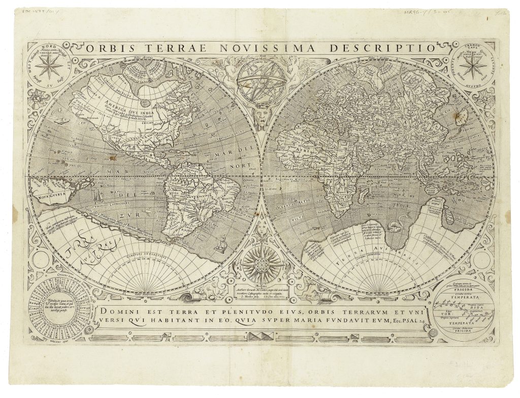
Jodocus Hondius I was a Flemish engraver, instrument maker, and map publisher whose career moved between Ghent, London, and Amsterdam. After leaving Ghent during the religious turmoil of the 1580s, he worked in London, where he became familiar with English maritime circles and with information surrounding Sir Francis Drake’s circumnavigation. This double-hemisphere world map is one of two world maps engraved by Jodocus Hondius I and published by Jean Le Clerc in Paris in 1602.
The map is known in three states: the first, dated 1602 and was printed before the upper-left corner of the copperplate was broken. According to Shirley, the plate broke across the upper-left corner between 1620 and 1621, and shortly afterwards the date was amended from 1602 to 1622, producing the second state. A third state is dated 1633 and retained evidence of the broken corner. The map is based on Rumold Mercator's 1587 double-hemisphere map, itself derived from Gerard Mercator’s 1569 world map. Hondius preserves Mercator’s large conjectural southern continent, labelled Terra Australis and carrying the names from Marco Polo's travel account, such as Beach and Maletur, placed south of Iava Maior. To the west, the landmass is described as Magellanica, named for Ferdinand Magellan, with an inscription noting that some believed it to be a continent.
Hondius introduces significant updates to Mercator's map, particularly in the depiction of South America. He removes the exaggerated bulge along the southwest coast, aligning it more closely with contemporary knowledge. He also presents Tierra del Fuego as a series of islands south of the Strait of Magellan. Among these islands are the Queen Elizabeth’s Islands, which Hondius attributes to Sir Francis Drake’s 1578 explorations. The lower cartouche quotes Psalm 24: 1–2: Domini est terra, et plenitudo ejus: orbis terrarum, et universi, qui habitant in eo. Quia ipse super maria fundavit eum. (The earth is the Lord’s, and the fullness thereof; the world, and all who dwell therein. For He has founded it upon the seas and established it upon the rivers). The hemispheres are surrounded by four circular diagrams including illustrations of the phases of the moon and Earth’s climatic zones, merging astronomical and geographical knowledge.
This example is closely connected with the other first-state example of the same map (199), as well as Le Clerc and Hondius’s oval world map, Nova universi orbis descriptio (110), which offers a related but compositionally different treatment of the world.
Hondius I, Jodocus (1563–1612)
Separate publication. Paris: Jean Le Clerc, 1602
1602, first
1622, second, after the top-left corner of the copperplate was broken between 1620 and 1621; 1633, third, with changes to Terra Australis and improved background engraving
Copperplate engraving
21
R2 Very rare - one or two copies appear on the market