
Plan der Stad en 't Kasteel Batavia Aanwyzing der Stad en Kasteels Punten
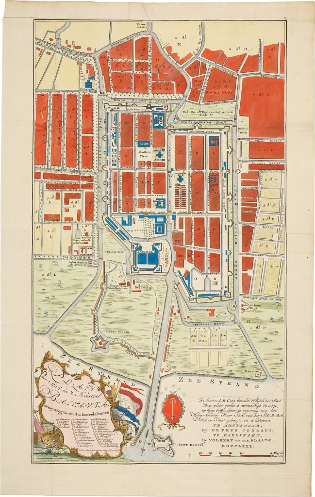
Peter Conrad, also known as Petrus Conradi, was an Amsterdam publisher associated with late eighteenth-century Dutch cartographic and topographical publishing. This plan of Batavia was published in 1780 by Petrus Conradi in Amsterdam and V. van der Plaats in Harlingen, and engraved by A. van Krevelt. It records the city as surveyed in 1770 under the direction of Governor-General Petrus Albertus van der Parra.
The plan shows Batavia, now Jakarta, as a walled colonial city structured by canals, streets, bastions, and administrative precincts. The straightened Ciliwung River, identified as the Groote Rivier, runs through the urban grid, while the surrounding canals, walls, and outlying fortifications define the city’s defensive perimeter. Within the walls, the plan distinguishes streets, canals, blocks, public buildings, churches, warehouses, hospitals, and civic spaces, keyed through a detailed numbered legend. The Kasteel Batavia, set near the harbour and roadstead, anchors the composition as the military and administrative centre of Dutch power in Java.
The plan is also a record of colonial urban management. Batavia’s orthogonal layout, canal network, bastioned defences, and keyed administrative divisions reflect the Dutch attempt to impose order on a low-lying, marshy coastal site while maintaining control over trade, movement, defence, and civic administration. At the same time, the plan preserves the layered geography of the city: the fortified European centre, the castle precinct, the riverine and canal system, and the surrounding rice fields and waterways beyond the walls.
Within the collection, this plan is closely connected with Gerard van Keulen’s chart of Batavia Road (349) and the English copy of that chart published by Robert Sayer and John Bennett (298), both of which show Batavia from the seaward approach. Gerard van Keulen’s two-sheet map of Java after Hadriaan Reland (261), the large Van Keulen firm blueback chart of Java (468), and Doncker II’s Nieuwe Paskaart van het Ylandt Java (422) place Batavia within the wider geography of Java and Dutch East Indies navigation. Together, these works show Batavia from different cartographic perspectives: as a fortified city, a harbour and roadstead, a VOC administrative centre, and part of the wider maritime geography of Java.
Conrad, Peter (fl. 1780)
Amsterdam: P. Conradi; Harlingen: V. van der Plaats, 1780
1780, first
Copperplate engraving
472
R2 Very rare - one or two copies appear on the market