
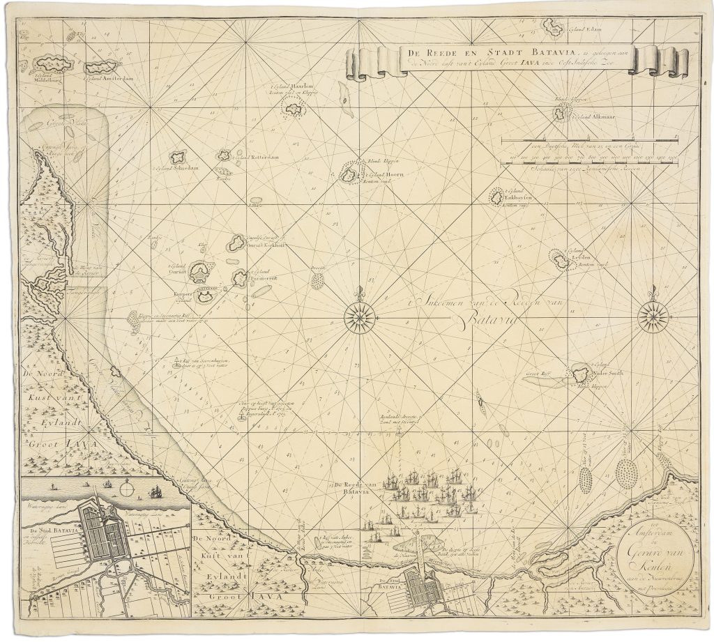
De reede en stadt Batavia, is geleegen aan de noord kust van 't eyland Groot Iava inde Oost Indische Zee
Gerard van Keulen was the second generation of the Van Keulen publishing house, In de Gekroonde Lootsman (“In the Crowned Pilot”), founded in Amsterdam by his father Johannes van Keulen I in 1678. The firm became one of the leading Dutch producers of maps, sea charts, atlases, and pilot books. Gerard was a talented engraver, mathematician, and Hydrographer to the Dutch East India Company, and became central to the development of the family business.
This chart of Batavia Road and the city of Batavia, present-day Jakarta, was first issued by Gerard van Keulen in 1728 for vol. 5 of De nieuwe groote lichtende Zee-fakkel. From 1753 onwards the chart was also included in vol. 6 of the Zee-fakkel, the restricted VOC volume prepared for navigation between the Cape of Good Hope and East Asia. The chart reflects Batavia’s role as the principal VOC centre in Asia and as a key harbour for ships moving through the Java Sea. The chart centres on Batavia Road, showing soundings along the coast, channels through the shallow approaches, nearby islands, reefs, and coastal features. An inset in the lower left details the layout of Batavia and its district, linking the roadstead to the administrative centre behind it. The chart also marks Onrust Island, an important fortified VOC repair and provisioning site in the approaches to Batavia.
Historical annotations record maritime incidents in the roadstead, including the grounding or loss of ships such as the Poppies in 1703 and the Rygersdall in 1705. These details made the chart both a practical navigational guide and a record of the hazards faced by vessels approaching the principal VOC harbour in Asia.
This chart is closely connected with Gerard van Keulen’s two-sheet map of Java after Hadriaan Reland (261), the English copy of Van Keulen’s Batavia road chart (298), Hendrik Doncker II’s Nieuwe Paskaart van het Ylandt Java (422), and the later large blueback chart of Java issued by the Van Keulen firm (468). Together, these works show the centrality of Batavia and Java to Dutch maritime navigation, administration, and trade in Southeast Asia.
Keulen, Gerard van (1678–1726)
De nieuwe groote lichtende Zee-fakkel, vol. 5, Amsterdam: Gerard van Keulen, 1728
1728, first
Copperplate engraving
349
R1 Extremely rare - occasionally seen on the market