
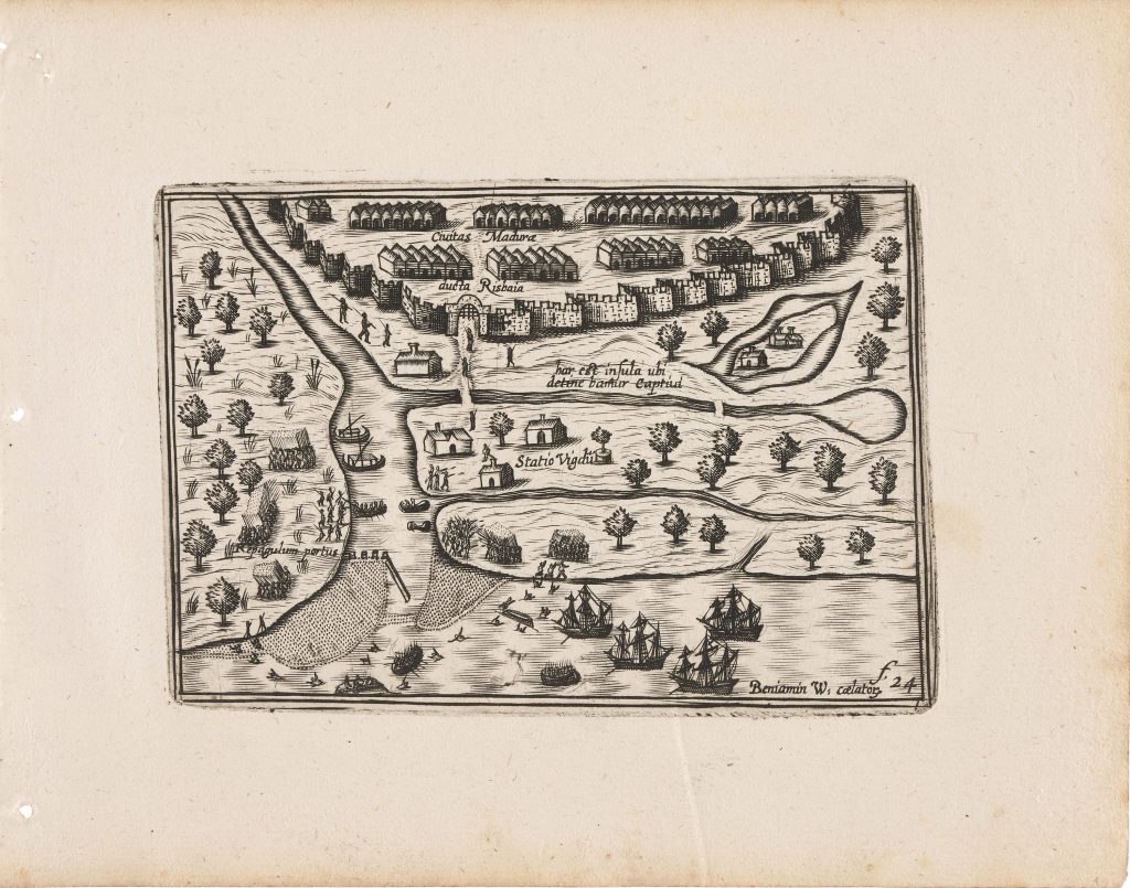
Civitas Madura ducta Risbaia
In 1649 Claes Jansz. Visscher reworked and expanded Barent Langenes’s Caert-thresoor, first published in Amsterdam in 1598 by Cornelis Claesz. as Tabularum geographicarum contractarum libri quatuor denuo recogniti. The compact atlas was divided into four parts: Europae (introduced by the title page 10), Asiae, Africae, and Americae. Alongside the inherited Langenes material, Visscher added twenty-three newly engraved maps, including plates relating to Dutch discoveries in Australia and the East Indies: Anthoni van Diemens Landt (11), ’t Landt van de Eendracht (12), Iava Maior (371), and two Benjamin Wright plates of Ternate–Tidore (369), and Madura, represented here. The atlas also incorporated revised versions of the earlier Hondius world maps, Typus orbis terrarum (292) and Iehova (293).
This engraving depicts the fortified settlement of Arosbaya, titled Civitas Madura dicta Arosbaya, on the island of Madura, off the north coast of Java. It was engraved by Benjamin Wright around 1601, sfollowing the return of the second Dutch voyage to the East Indies in 1598–1600, led by Jacob van Neck with Wybrand van Warwijck as vice-admiral. Although produced in connection with the publication of the voyage account, the plate does not appear in surviving copies of the journals issued in 1601 and is first recorded in Visscher’s 1649 atlas. Unlike the Ternate–Tidore plate (369), which is primarily coastal and navigational, this image functions as a prospect view combining topography and narrative. The walled city dominates the upper portion of the composition, rendered schematically with continuous defensive walls and densely arranged buildings, emphasising both fortification and urban concentration. The inscription Hic est insula ubi detinebatur captivus (“Here is the place where the captive was held”) refers to the detention of a local ruler, situating the scene within a specific episode of early Dutch engagement in the region.
In the foreground, Dutch ships lie anchored offshore, with longboats moving between ship and shore. Small figures are shown loading or unloading goods, reinforcing the commercial focus of the image. The labels Statio ("guard station") and Repagulum portus ("harbour barrier" or "defensive works") identify key military positions along the waterfront. Together, these elements indicate that the plate records not merely a town view but a site of strategic and logistical importance during the early phase of Dutch expansion along the north coast of Java.
Within the collection, this view is closely connected with Wright’s Ternate–Tidore plate (369), which presents another site connected with the second Dutch voyage to the East Indies.
Wright, Benjamin (1575–1613)
Tabularum geographicarum contractarum libri quatuor denuo recogniti, Amsterdam: Claes Jansz. Visscher, 1649
1649, first
Copperplate engraving
370
R1 Extremely rare - occasionally seen on the market