
Theatrum orbis terrarum
Abraham Ortelius was a Flemish cartographer, editor, and antiquarian whose Theatrum orbis terrarum, first published in Antwerp in 1570, became the defining printed atlas of the later sixteenth century (252for the 1584 edition). This engraved title page comes from the 1603 Latin edition issued in Antwerp by Jan Baptist Vrients, who acquired the Ortelius publishing rights after Ortelius’s death and continued to expand and reissue the atlas.
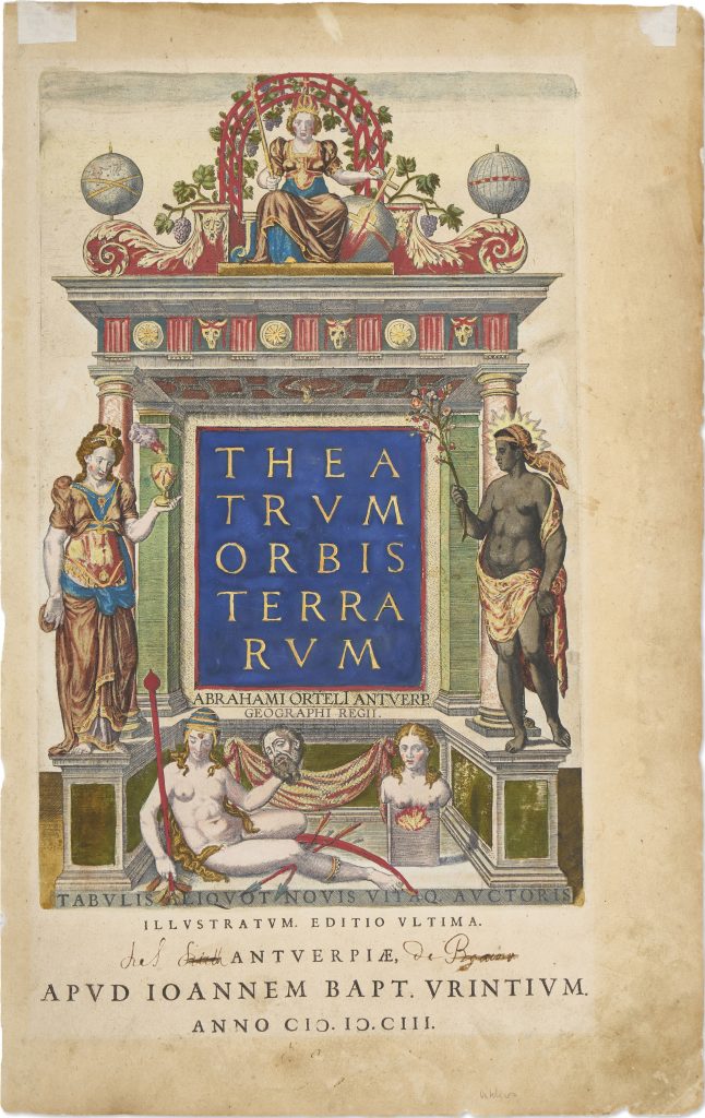
The title page presents the atlas as a theatre of the world. The architectural frame encloses the title Theatrum orbis terrarum and is surrounded by allegorical figures representing known parts of the world and the still speculative southern continent. Ortelius included Adolf van Meetkerke’s poem Frontispicii explicatio in the preliminary pages of the atlas; the poem explains the figures, their attributes, and their relative positions within the composition. At the top, Europe sits as a crowned queen on a throne beneath a vine-covered arbour. She holds a sceptre in one hand and a rudder in the other, symbols of sovereignty, command, and maritime control. Her elevated position reflects Europe’s imagined supremacy in the atlas’s worldview: she presides over the Old World and, through Iberian expansion, claims new authority over the newly encountered world.
To Europe’s right stands Asia, richly dressed and holding a censer, an emblem of incense, luxury goods, and the wealth Europeans associated with the East. To Europe’s left stands Africa, her head surrounded by sunbeams in reference to the heat of the continent. She holds a sprig of balsam, alluding to aromatic products and ancient traditions of African and eastern trade. The contrast between Asia’s elaborate costume and Africa’s simpler attributes reflects European hierarchies of knowledge and value, as well as the limited European understanding of Africa’s interior. Below the other continents reclines America, shown naked except for a feathered headdress, ornaments, and bells around her calves. Her bow, arrows, club, severed head, and hammock draw on European conventions for representing the New World as exotic, violent, and culturally “other.” These attributes reflect early modern stereotypes, including associations with cannibalism, rather than neutral ethnographic description. America’s position beneath Europe reinforces the hierarchical structure of the image.
Opposite America appears the speculative fifth continent, Magellanica, represented as a truncated female bust. Her incomplete form is significant: unlike Europe, Asia, Africa, and America, she is not given a full body because the southern continent remained geographically uncertain. The name links the region to Ferdinand Magellan and to the long-standing idea that Tierra del Fuego might be the northern edge of a larger southern land. In the title-page programme, Magellanica is therefore present but unresolved — imagined, named, and allegorised before it was known. This example is also important because the verso carries the Spanish Habsburg coat of arms, underscoring the political setting in which Ortelius’s atlas circulated. Antwerp was under Habsburg rule, and the atlas’s representation of global geography is closely bound to Iberian expansion, imperial authority, and the ordering of newly acquired geographical knowledge.
Ortelius, Abraham (1527–1598)
Theatrum orbis Terrarum, Antwerp: Gielis Coppens van Diest, 1570
1603, Latin edition, Jan Baptist Vrients issue
Copperplate engraving
384
R1 Extremely rare - occasionally seen on the market