
Gouvernement Des Etats des Sept Provinces Unies
Zacharie Châtelain was a Huguenot publisher and compiler active in Amsterdam, now generally regarded as the principal compiler of the Atlas historique, although the work has traditionally been attributed to Henri Abraham Châtelain. Published between 1705 and 1720, the Atlas historique combined geography, chronology, history, genealogy, politics, religion, commerce, and travel, making it one of the most ambitious illustrated geographical encyclopaedias of the early eighteenth century. Its maps, views, diagrams, and historical essays were intended not simply to describe the world, but to place geographical knowledge within a broader framework of history and human affairs. The work was also rich in material concerning civil, military, commercial, and ecclesiastical governance, including plates on the Dutch East India Company (249) and this plate on the States of the Seven United Provinces.
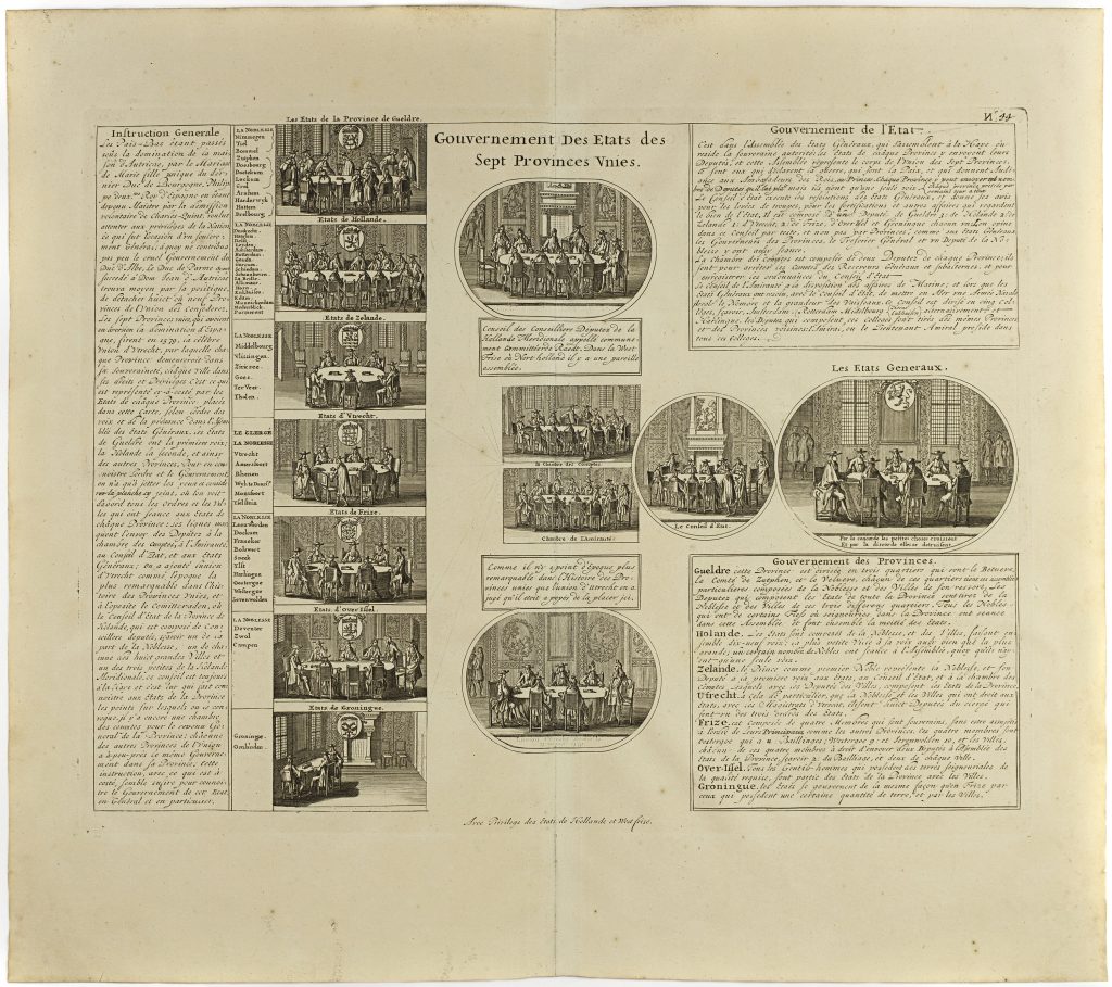
This engraving explains the government of the Seven United Provinces, the federal republic formed by the northern Netherlands after the revolt against Habsburg Spain. Rather than mapping the Dutch Republic geographically, it presents its political structure through labelled vignettes, coats of arms, council chambers, lists, and explanatory text. The plate shows the individual provinces and the collective machinery of government that held them together. Along the left are vignettes representing the provincial States, including Gelderland, Holland, Zeeland, Utrecht, Friesland, Overijssel, and Groningen, accompanied by lists of towns and noble representatives. The central scenes refer to key political and administrative institutions, including the council of deputies, the chamber of accounts, the admiralty, and the Union of Utrecht of 23 January 1579, the foundational agreement through which the provinces bound themselves together. On the right are further scenes and text panels describing the Council of State, the States General, and the government of the provinces.
A motto beneath the States General vignette reads: par la concorde les petites choses croissent et par la discorde elles se detruisent — “through concord small things grow, and through discord they are destroyed.” The motto gives the plate its political argument: the strength of the Dutch Republic lay in negotiated union among separate provinces, while discord threatened its stability. Although not a map in the narrow sense, the plate belongs naturally within the Atlas historique. Châtelain treated geography as inseparable from government, commerce, military organisation, religion, and history. In that context, this engraving helps explain the institutional framework behind the Dutch Republic’s domestic power and overseas expansion. It should be read alongside the related plate on the Dutch East India Company (249), the world map of Dutch possessions (248), and the map of Java and Batavia (353).
Chatelain, Henri Abraham (1684–1743)
Atlas historique, ou nouvelle introduction à l’histoire, à la chronologie & à la géographie ancienne & moderne, vol. 1, Amsterdam: L’Honoré & Châtelain, 1705
TBA
Copperplate engraving
250
R3 Uncommon - dealers can usually obtain a copy