
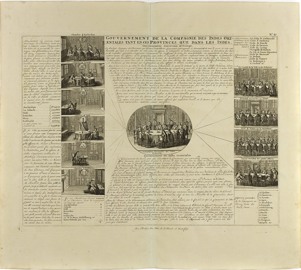
Gouvernement de la Compagnie des Indes Orientales tant en ces Provinces que dans les Indes
Zacharie Châtelain was a Huguenot publisher and compiler active in Amsterdam, now generally regarded as the principal compiler of the Atlas historique, although the work has traditionally been attributed to Henri Abraham Châtelain. Published between 1705 and 1720, the Atlas historique combined geography, chronology, history, genealogy, politics, religion, commerce, and travel, making it one of the most ambitious illustrated geographical encyclopaedias of the early eighteenth century. Its maps, views, diagrams, and historical essays were intended not simply to describe the world, but to place geographical knowledge within a broader framework of history and human affairs. The work was also rich in material concerning civil, military, commercial, and ecclesiastical governance, including this plates on the Dutch East India Company and the States of the Seven United Provinces (250).
This engraved plate explains the government of the Dutch East India Company, or VOC, both in the United Provinces and in the Indies. Rather than mapping territory in the usual sense, it presents the institutional structure through which Dutch overseas trade, administration, and colonial power were organised. The plate is arranged as a series of vignettes, lists, and explanatory text panels. At the centre is the council chamber of the Heeren XVII, the seventeen directors of the VOC. On the left are the six regional chambers of the company in the Dutch Republic: Amsterdam, Zeeland/Middelburg, Delft, Rotterdam, Hoorn, and Enkhuizen. Their accompanying figures and interiors show the domestic institutional framework from which the company’s overseas operations were directed.
On the right, the plate turns to VOC government in the Indies. The vignettes and lists describe the Governor-General, the Council of the Indies, the sovereign council or state council, judicial bodies, and councils concerned with smaller affairs. Additional lists name the principal places under VOC authority or influence, extending from the Cape of Good Hope to Ceylon, the Moluccas, Java, Bengal, Siam, Japan, and other parts of Asia. The subject is closely related to the Dutch Republic’s maritime and commercial expansion. The VOC was not merely a trading company: it held powers to make treaties, build forts, maintain armed forces, administer settlements, and regulate commerce across a wide network of Asian ports and territories. In the Atlas historique, this plate helps readers understand the institutional machinery behind Dutch commercial geography.
This engraving is closely connected with Châtelain’s world map of Dutch possessions (248), his plate on the government of the Seven United Provinces (250), and his map of Java and Batavia (353). Together, these works show how the Atlas historique connected maps, political institutions, and overseas commerce into a single explanatory framework.
Chatelain, Henri Abraham (1684–1743)
Atlas historique, ou nouvelle introduction à l’histoire, à la chronologie & à la géographie ancienne & moderne, vol. 1, Amsterdam: L’Honoré & Châtelain, 1705
TBA
Copperplate engraving
249
R3 Uncommon - dealers can usually obtain a copy