
Carte de l’Ile de Java
Zacharie Châtelain was a Huguenot publisher and compiler active in Amsterdam, now generally regarded as the principal compiler of the Atlas historique, although the work has traditionally been attributed to Henri Abraham Châtelain. Published between 1705 and 1720, the Atlas historique combined geography, chronology, history, genealogy, politics, religion, commerce, and travel, making it one of the most ambitious illustrated geographical encyclopaedias of the early eighteenth century. Its maps, views, diagrams, and historical essays were intended not simply to describe the world, but to place geographical knowledge within a broader framework of history and human affairs. Volume V, first published in 1719, focused mainly on Asia and Asian trade. It presented the region through maps, historical essays, accounts of commerce and travel.
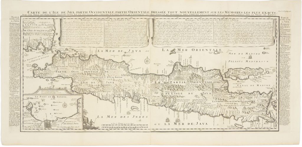
The long title emphasises not only the geography of Java but also Dutch commercial and colonial activity on the island. It includes a table of principal towns, the locations of Dutch trading posts and possessions, and notes on the way the Dutch established themselves in Batavia.. The map therefore combines geography with commercial and colonial information, making it closely related to Chatelain’s plate on the government of the Dutch East India Company (249) and his world map of Dutch overseas possessions (248).
Châtelain's treatment of Java drew on recent European scholarship and geographic information, including material associated with Hadrien Reland, the Dutch scholar whose work on the Indonesian archipelago helped shape European understanding of the region. The map identifies towns, rivers, mountains, forests, cultivated areas, grazing lands, reefs, and navigational hazards, combining coastal mapping with information about the island’s interior. The surrounding text panels and cartouches expand the map’s purpose beyond topography. They discuss Java’s cities, landscape, history, flora, fauna, inhabitants, and Dutch commercial presence. In the lower-left quadrant, an inset plan of Batavia, now Jakarta, gives particular prominence to the VOC’s principal base in the region.
At the time of its publication, the map was one of the more detailed printed European representations of Java. Earlier printed maps, including Pieter van der Aa’s 1714 treatment, showed the northern coast with greater confidence than the southern coast, which was often marked as Parte Incognita, or “unknown part.” Chatelain’s more developed southern coastline suggests access to information beyond the usual published sources, at a time when the VOC closely guarded many of its manuscript charts and navigational materials. The map’s later influence is notable. Johannes van Keulen II published a related two-sheet map of Java in 1728 (261), attributed to Hadrien Reland and included in De nieuwe groote lichtende Zee-fakkel. The close relationship between the two maps suggests that Châtelain’s map was part of a wider exchange of information about Java between illustrated atlas publishing and practical Dutch sea-chart production.
Chatelain, Henri Abraham (1684–1743)
Atlas historique, ou nouvelle introduction à l’histoire, à la chronologie & à la géographie ancienne & moderne, vol. 5. Amsterdam: L’Honore & Chatelain, 1719
1719, first
Copperplate engraving
353
R3 Uncommon - dealers can usually obtain a copy