
Kort over egnene Omkring Batavia tillige med Prospecten as denne Stad til den Almindelige Historie over Reiser
Jonas Haas was a German-born engraver active in Copenhagen, where he produced maps, plans, views, and book illustrations for Danish publishers. This map was engraved by Jonas Haas for Almindelige Historie over Rejser, the Danish translation of Prévost's Histoire générale des voyages, and was issued in vol. 12 in 1750.
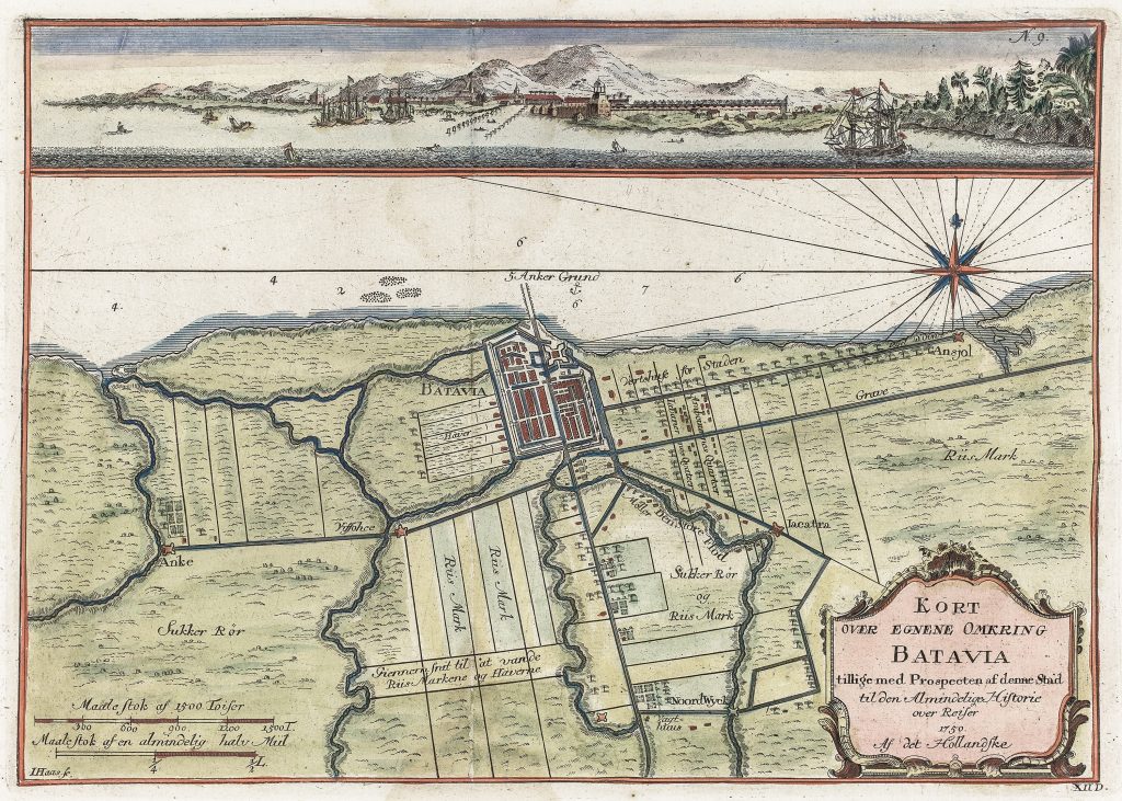
The sheet combines two kinds of information. The main map shows Batavia and its surrounding district on the north coast of Java, including rivers, roads, canals, cultivated land, sugar fields, markets, and nearby settlements. The city itself appears within its fortified outline, connected to the coastline and to inland routes. Across the upper part of the sheet is a coastal prospect of Batavia, showing the city and harbour from the sea, with ships offshore and mountains rising in the background.
The map presents Batavia as both a maritime and territorial centre. Soundings and anchorage information appear along the coast, while inland labels such as Sukker Rør and Riis Mark identify sugar cane and rice fields. The surrounding roads and canals show the city’s dependence on a managed hinterland as well as on seaborne trade. By combining map, prospect, hydrographic detail, and cultivated landscape, the sheet gives a fuller picture of how eighteenth-century European readers were encouraged to understand Batavia and its environs.
Within the collection, this map is closely connected with Haas’s companion plan of the city and fortress of Batavia (189). Where 189shows the internal structure of the fortified city, 192places Batavia within its wider coastal and agricultural setting. It also relates to Dutch and English charts of Java and the Sunda Strait, including Hendrick Doncker II’s chart of Java (422) and Samuel Dunn’s chart of the Sunda Strait (419), which show the continuing importance of Batavia and its approaches within European maritime geography.
Haas, Jonas (1720–1775)
Prévost, Antoine François, Histoire générale des voyages, Paris, 1746–1759
1750, first Danish edition
Copperplate engraving
192
R3 Uncommon - dealers can usually obtain a copy