
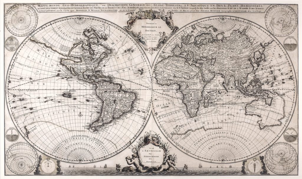
Mappe-monde geo-hydrographique, ou description generale du globe terrestre et aquatique, en deux plans-hemispheres
Pierre Mortier was an Amsterdam publisher who played an important role in bringing French cartography into the Dutch atlas market. After training in Paris in the early 1680s, he returned to Amsterdam and obtained privileges to publish French geographical works in the Dutch Republic. His atlases therefore sit between two cartographic worlds: French geographical innovation and Dutch engraving, printing, and commercial distribution.
This richly ornamented double-hemisphere world map was first published for Mortier’s Atlas nouveau in Amsterdam around 1700. Its title describes the map as geo-hydrographique presenting the globe as both land and water. The composition combines global geography, oceanic routes, polar projections, allegorical decoration, and speculative regions. The title cartouche is framed by female personifications of the four continents, while the lower cartouche presents a maritime fantasy with a whale, mermaid, merman, and Mortier’s imprint. The map is especially interesting for its mixture of updated geography and conjecture. In North America it shows the Mer de l’Ouest, or Sea of the West, an imagined inland sea extending deep into the continent. At the same time, Nouvelle Hollande records Dutch discoveries around Australia, including the western and northern coasts and Abel Tasman’s 1644 voyage, noted in the inscription Hollandia Nova: detecta Aº 1644. The map therefore combines the latest European geographical ambitions with regions that remained only partly known. Nouvelle Hollande incorporates the results of seventeenth-century Dutch coastal encounters, including Willem Jansz. in the Gulf of Carpentaria, Dirk Hartog and Frederik de Houtman on the western coast, the Leeuwin contact of 1622, Jan Carstensz. and Pieter van Colster in Cape York and Arnhem Land, Pieter Nuyts’s voyage in the ’t Gulden Zeepaert, and Gerrit Frederiksz. de Witt’s observations of 1628. Australia is presented not as a completed continent, but as a partly known coastline built from Dutch voyage reports.
The routes of Ferdinand Magellan, Álvaro de Mendaña, Pedro Fernandes de Queirós, Jacques Le Maire, and Willem Cornelisz. Schouten are also shown. These tracks connect the map to the history of global navigation and to the gradual European mapping of the Pacific and southern oceans. Four polar projections in the corners add a scientific frame to the otherwise theatrical design. The map exists in several undated states. Tony Campbell identifies three principal forms: an issue with the Pierre and David Mortier imprint, an issue with Pierre Mortier’s sole imprint, and a later Covens & Mortier issue. Rodney Shirley, however, suggested that the Pierre Mortier-only imprint may represent the first state, placing the map close to 1700. Because this example bears Pierre Mortier’s sole imprint, it is best described cautiously as an early issue, c. 1705.
Within the collection, this map is closely connected with other world maps that combine global navigation with conjectural southern or Pacific geography, including Paulus Merula’s Totius orbis cogniti universalis descriptio (59), Pieter van den Keere’s world map (109), and Michael Mercator’s America map (464). It also relates to maps of Australia and the Pacific that preserve Dutch discoveries in Nouvelle Hollande, including Johannes Loots’s Indian Ocean chart (4), Johannes van Loon’s Pacific chart (290), and Jan de Lat’s map of Nieu Holland (389).
Mortier, Pierre (1661–1711)
Atlas nouveau, contenant toutes les parties du monde, Amsterdam: Pierre Mortier, 1700
1705, Pierre Mortier sole-imprint issue
Pierre and David Mortier imprint, c. 1702–4; later Covens & Mortier issue, c. 1721
Copperplate engraving
140
R2 Very rare - one or two copies appear on the market