
Nova totius terrarum orbis geographica ac hydrographica tabula
Pieter van den Keere was a Flemish engraver, mapmaker, publisher, and globe maker who worked in London and Amsterdam. Around 1584 he left Ghent during the religious upheavals in the Low Countries and settled in London, where he trained as an engraver in the circle of his brother-in-law Jodocus Hondius I. His sister Coletta van den Keere married Hondius in 1587. In the 1590s Van den Keere moved to Amsterdam, where he became an important engraver and publisher within the Dutch map trade.
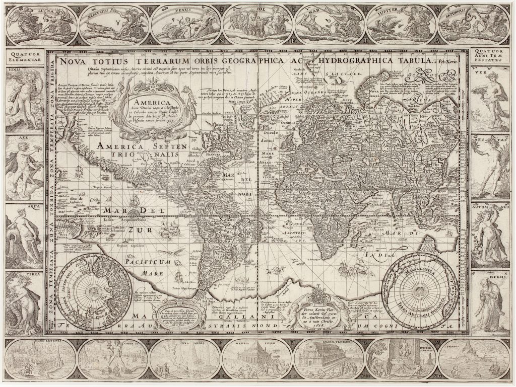
This large world map was first published separately by Van den Keere in Amsterdam in 1608. Its overall design follows Willem Jansz. Blaeu’s 1606 world map (9), but Van den Keere altered the plate in important ways. He reduced the outer framing, retained a prominent network of rhumb lines from three compass roses, and added a fuller body of explanatory text. The decorative borders use the same broad programme as Blaeu’s map: The upper border shows the Septem Planetae, or Seven Planets: Luna, Mercurius, Venus, Sol, Mars, Jupiter, and Saturn. The side borders present the four elements, Ignis, Aer, Aqua, Terra, and the four seasons, Ver, Aestus, Autumnus, Hyems. The lower border depicts the Seven Wonders of the Ancient World: the walls or gardens of Babylon, the Colossus of Rhodes, the Pyramids of Egypt, the Mausoleum of Halicarnassus, the Temple of Diana at Ephesus, the statue of Jupiter Olympius, and the Pharos of Alexandria.
The added inscriptions give the map a more discursive character than Blaeu’s version. Several notes concern recent Arctic exploration and the possibility of a northern passage between the Atlantic and Pacific. In Terra Australis, Van den Keere includes references to Magellanica, Psittacorum regio, and the Marco Polo-derived names Beach, Lucach, and Maletur, combining inherited southern-continent geography with more recent exploration reports. In a cartouche in Magellanica Van den Keere’s emblem appears: a clock with a skull at its centre, surrounded by flames, accompanied by his Flemish motto Wie gaat ick keere (“Many go, I shall return”). Near Tierra del Fuego, the map includes a note describing a vessel made from hides used by the inhabitants of the Strait of Magellan, a detail borrowed from Jodocus Hondius I’s 1606 map of the Americas. The result is a world map that adapts Blaeu’s visual structure while giving greater weight to textual explanation, especially at the northern and southern edges of the known world.
Within the collection, this map is directly connected with the later 1622 Lons world map (122), which takes Van den Keere’s 1608 map as its prototype and adds Le Maire and Schouten’s Pacific route. It also relates to Willem Jansz. Blaeu’s 1606 world map (9), Jodocus Hondius I’s Orbis terrae novissima descriptio (199), and Van den Keere’s smaller world map Orbis terrarum typus (217). Ex Loeb Larocque collection, Paris
Keere, Pieter van den (1571–1646)
Separate publication. Amsterdam: Pieter van den Keere, 1608
1608, first
Copperplate engraving
109
R1 Extremely rare - occasionally seen on the market