
Indiae orientalis insularumque adiacientium typus
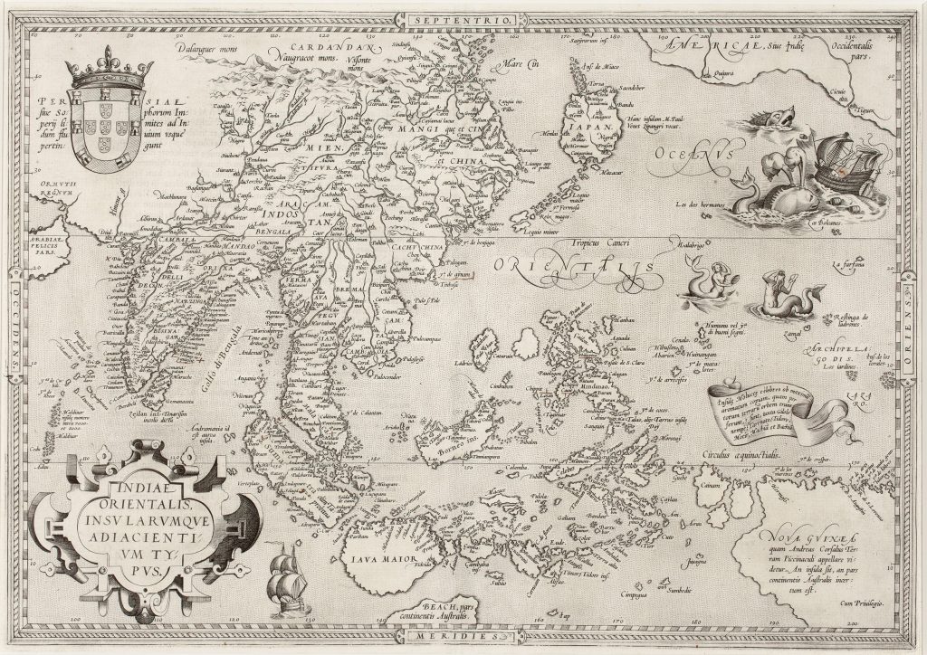
Abraham Ortelius was a Flemish cartographer, editor, and antiquarian whose Theatrum orbis terrarum, first published in Antwerp in 1570, became the defining printed atlas of the later sixteenth century (252for the 1584 edition). This map was one of the major Asian regional maps in the first edition of the atlas, extending from Arabia, Persia, India, and China to Japan, the Philippines, the Moluccas, New Guinea, and the northern edge of the southern continent.
The map reflects the importance of Portuguese and Iberian geographical knowledge in European mapping of maritime Asia. The Portuguese royal arms at upper left, together with the accompanying inscription, asserts Portugal’s connection with the region and with the sea routes to the East Indies. The map’s density of place names, islands, channels, and coastal settlements records a world understood through navigation, trade, and empire. The Moluccas occupy a crucial position on the map. Islands such as Ternate, Tidore, Motir, Machian, and Bachian are individually named, reflecting their significance in the spice trade. These islands were not marginal details for a sixteenth-century European viewer: they were among the most commercially valuable places on the map, associated with cloves, nutmeg, mace, and intense Portuguese, Spanish, and later Dutch rivalry. Ortelius’s depiction of Southeast Asia combines recognisable geography with substantial uncertainty. Sumatra, Java, Borneo, the Malay Peninsula, the Philippines, and the coast of China are shown with considerable detail, but their forms and relative positions remain unstable. Japan appears in an unusual configuration, and the seas between China, the Philippines, and the Moluccas are populated with sea creatures, islands, and explanatory notes, giving the region both navigational and imaginative force.
The southern portion of the map is especially significant for the collection. Below Java appears Beach, pars continentis Australis, identifying Beach as part of the southern continent. This name was derived from the European reception of Marco Polo’s Locach and related textual traditions, but it was displaced southwards and absorbed into the imagined geography of Terra Australis. Ortelius’s map therefore links the East Indies directly to the southern-continent tradition. New Guinea is shown as a large landmass in the lower right, labelled Nova Guinea, with a note explaining that it had formerly been called Piccinacoli and that it remained uncertain whether it was an island or part of the southern continent. This uncertainty is one of the map’s most revealing features. Ortelius does not present the southeast as fully known; rather, he shows a region where travel reports, inherited names, and speculation overlap.
Within the collection, this map is closely connected with Ortelius’s world map (81), where Terra Australis nondum cognita dominates the southern hemisphere, and Maris Pacifici (221and 118), where New Guinea, the Solomon Islands, the Moluccas, and Terra Australis sive Magellanica are placed within a wider Pacific framework.
Ortelius, Abraham (1527–1598)
Theatrum orbis Terrarum, Antwerp: Gielis Coppens van Diest, 1570
1570, first
Copperplate engraving
106