
Der Hollaendisch-Ostindianischen Compagnie weltberühmte Haupt-Handels und Niederlags-Stadt Batavia
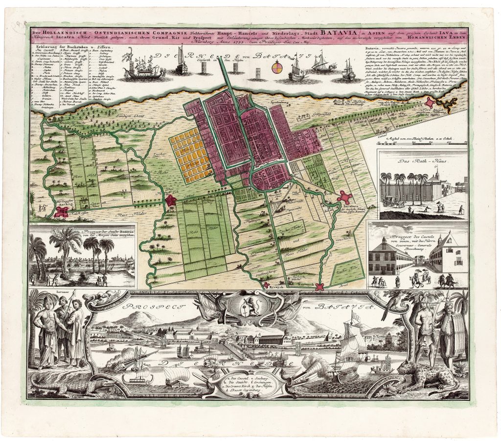
Homann Heirs was the Nuremberg publishing firm that continued the cartographic business founded by Johann Baptist Homann after his death in 1724. By the 1730s the firm was issuing large, decorative atlas maps for a European readership interested in commerce, empire, and overseas cities. This 1733 sheet presents Batavia, now Jakarta, as the principal Asian headquarters of the Dutch East India Company, or VOC.
The full title describes Batavia as the Dutch East India Company’s world-famous principal trading and settlement city in Asia, located on the island of Java in the kingdom of Jacatra, and shown according to both ground plan and prospect. The sheet combines a detailed city plan with views, explanatory keys, and historical text. At the centre is the walled city of Batavia, with its canals, streets, gates, fortifications, public buildings, suburbs, and cultivated surroundings. Above and below are prospects of the city and roadstead, showing Batavia from the sea with ships, harbour works, public buildings, and mountains in the distance. The inscription at upper right gives a compact history of the city. It states that Batavia, formerly called Jacatra, was founded by the Dutch in 1619 and was approximately 3, 600 old Dutch nautical miles from Amsterdam and twelve miles from Bantam. It praises the city’s ordered plan, strong defences, and harbour, claiming that Batavia had withstood three sieges by Javanese rulers and served as the VOC’s principal base in the Indies. The inscription also describes a regular pattern of winds that assisted small vessels moving in and out of the harbour, presenting Batavia as a place shaped by both urban planning and maritime advantage.
The sheet also emphasises Batavia’s cosmopolitan population and administrative importance. The text refers to Javanese, Chinese, Malays, Muslims, Malabars, Dutch, French, and Portuguese residents, and notes the use of Dutch, Malay, Portuguese, and Chinese languages. As the seat of the governor-general, Batavia is presented as the administrative centre from which the VOC governed its East Indian territories. The numbered key identifies important buildings and spaces, while the insets include the town hall, the castle, the council chamber, and the governor-general’s guard, reinforcing the city’s civic, military, and commercial character. At the bottom, the large prospect titled Prospect von Batavia von der Morgen Seite anzusehen — “View of Batavia from the east” — presents the city from the sea. The scene shows tBatavia’s castle, harbour works, public buildings, shipping, and mountainous backdrop, complementing the central ground plan with a pictorial view of the city’s maritime setting.
Within the collection, this map is closely connected with other Batavia-related works, including Jonas Haas’s plan of the city and fortress (189), Haas’s map of the environs of Batavia with a coastal prospect (192), François Xavier Habermann’s optical view of the town hall and great square (194), and the English harbour views from John Harris’s Navigantium atque itinerantium bibliotheca (208). Together, these works show Batavia as a fortified city, a managed colonial landscape, a civic spectacle, and a maritime centre. It also relates to charts of Java and the Sunda Strait, including Hendrick Doncker’s chart of Java (422) and Samuel Dunn’s chart of the Sunda Strait (419), which place Batavia within the wider navigational geography of the region.
Homann Heirs (firm, active 1730–1848)
Stadt-Atlas, oder: Schauplatz beruhmter Stadte, Vestungen, Prospeckte, Gegenden, Grundrisse, Belagerungen, etc.. Nuremburg, Homann Heirs, 1733
1733, first
Copperplate engraving
62
R2 Very rare - one or two copies appear on the market