
Pars orbis
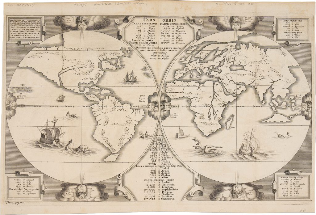
This map appears on page 553 of vol. 6 of Critici sacri, published in London by Thomas Roycroft in 1660.
Produced after the English Civil War, this large compilation of biblical scholarship brought together theological and exegetical writings by leading Continental scholars.
It reflects the renewed engagement of Restoration England with European biblical learning.
The map derives from the world map prepared for Benedictus Arias Montanus’s contribution to the Plantin Polyglot Bible, first published in Antwerp in 1572 (111).
It preserves the original map’s theological structure, presenting the world not only as geographic space, but as a framework for sacred history.
Arranged in two hemispheres, the map traces the descendants of Noah’s sons—Shem, Ham, and Japheth—across the known world after the Flood.
A central panel lists genealogical names in Hebrew and Latin, while alphabetical and numerical references link these names to places on the map.
Geography is therefore used to organise biblical descent, migration, and settlement.
This example was printed from the third copperplate, issued in London in 1660.
It can be distinguished from the earlier Antwerp plates by the text “Tom: VI. pag. 553.” in the lower-left margin.
In this plate, the wind heads are shown with closed eyes, and the sea is revised with different ships and sea creatures.
These changes show that the London map was not a simple reissue, but a newly engraved version adapted for a seventeenth-century English scholarly context.
Within the collection, this map should be read most directly with the related Arias Montanus / Plantin Polyglot Bible material (111), from which the design ultimately derives.
It also relates with other works that use world geography to organise sacred history and theological interpretation, especially the Wittenberg World Map, or Daniel’s Dream Map (476).
Arias Montanus, Benedictus (1527–1598)
Biblia Sacra [Polyglot Bible], vol. 8, Antwerp: Christopher Plantin, 1572
1660, London
1571, first plate, state 1; 1572, first plate, state 2; after 1572, second plate
Copperplate engraving
474
R2 Very rare - one or two copies appear on the market